Pokhvistnevo geodata
Pokhvistnevo (Samara Oblast) is a populated place; located in Russia in Europe/Samara (GMT+4) time zone. With population of 28,300 people, there are 691 cities with bigger population in this country. Compared to other cities in Russia, 57.8% of cities are located further ↑North; 63.9% of cities are located further ←West and 80.6% of cities have higher elevation than Pokhvistnevo. Note1


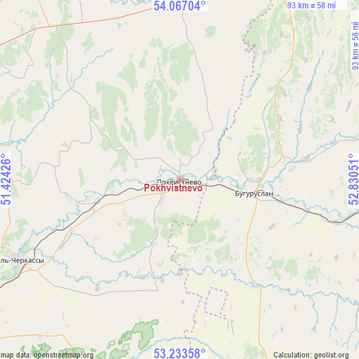
Pokhvistnevo GPS coordinates[2]
53° 39' 8.532" North, 52° 7' 38.568" East
| Map corner | latitude | longitude |
|---|---|---|
| Upper-left | 54.06704°, | 51.42426° |
| Center: | 53.65237°, | 52.12738° |
| Lower-right: | 53.23358°, | 52.83051° |
| Map W x H: | 92.7×92.7 km | = 57.6×57.6mi |
| max Lat: | 73.50819° ⇑57.8% North |
| Pokhvistnevo: | 53.65237° |
| min Lat: | ⇓42.2% South 41.28413° |
| min Long | Pokhvistnevo | max Long |
| -179.12198° | 52.12738° | 179.35046° |
| W 63.9%⇐ | ⇒36.1% E |
Elevation
Elevation of Pokhvistnevo is 69 m = 226 ft, and this is 133.6 m = 438 ft below average elevation for this country.
| Max E: |
2518 m = 8261 ft | 80.6% |
| Avg. | 202.6 m = 665 ft | |
| Pokhvistnevo | 69 m = 226 ft | |
Min E: |
-28 m = -92 ft | 19.4% |
See also: Russia elevation on elevation.city.
Geographical zone
Pokhvistnevo is located in North temperate zone (between Tropic of Cancer and the Arctic Circle). Distance of this North polar circle is 1435.6 km =892 mi to North.| Distance of | km | miles | from Pokhvistnevo |
|---|---|---|---|
| North Pole | 4041.5 | 2511.3 | to North |
| Arctic Circle | 1435.6 | 892 | to North |
| Tropic Cancer | 3359.7 | 2087.6 | to South |
| Equator | 5965.6 | 3706.9 | to South |


Nearby cities:
15 places around Pokhvistnevo: (largest is in red/bold)
• Asekeyevo
45 km =28 mi,  101°
101°
• Borskoye
74 km =46 mi,  201°
201°
• Buguruslan
20.7 km =12.9 mi,  89°
89°
• Isakly
66.1 km =41.1 mi,  323°
323°
• Kamyshla
51.7 km =32.1 mi,  1°
1°
• Kinel’-Cherkassy
47.6 km =29.6 mi,  244°
244°
• Klyavlino
68.4 km =42.5 mi,  354°
354°
• Koltubanovskiy
79.4 km =49.3 mi,  184°
184°
• Krotovka
75.4 km =46.9 mi, 237°
• Otradnyy
60.2 km =37.4 mi, 239°
• Podsolnechnoye
56.3 km =35 mi,  187°
187°
• Sernovodsk
64.6 km =40.1 mi,  297°
297°
• Severnoye
56.1 km =34.9 mi,  29°
29°
• Sukhodol
66.2 km =41.1 mi,  294°
294°
• Surgut
67.8 km =42.1 mi, 296°
In other languages:
- In Spanish: Pójvistnevo
- In German: Pochwistnewo
- In Italian: Pochvistnevo
- In Russian: Похвистнево
- In Chinese: 波赫維斯特涅沃
Sources, notices
• [Note1] Compared only with cities in Russia existing in our database
• [Src1] Map data: © OpenStreetMap contributors (CC-BY-SA)
• [Src2] Other city data from geonames.org with taken over terms of usage.
• [Src3] Geographical zone / Annual Mean Temperature by Robert A. Rohde @ Wikipedia
