Isakly geodata
Isakly (Samara Oblast) is a populated place; located in Russia in Europe/Samara (GMT+4) time zone. With population of 4,417 people, there are 2903 cities with bigger population in this country. Compared to other cities in Russia, 54% of cities are located further ↑North; 63.5% of cities are located further ←West and 78% of cities have higher elevation than Isakly. Note1


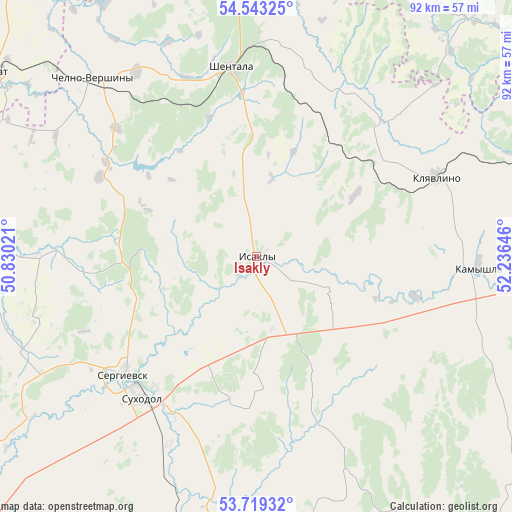
Isakly GPS coordinates[2]
54° 7' 59.988" North, 51° 31' 59.988" East
| Map corner | latitude | longitude |
|---|---|---|
| Upper-left | 54.54325°, | 50.83021° |
| Center: | 54.13333°, | 51.53333° |
| Lower-right: | 53.71932°, | 52.23646° |
| Map W x H: | 91.6×91.6 km | = 56.9×56.9mi |
| max Lat: | 73.50819° ⇑54% North |
| Isakly: | 54.13333° |
| min Lat: | ⇓46% South 41.28413° |
| min Long | Isakly | max Long |
| -179.12198° | 51.53333° | 179.35046° |
| W 63.5%⇐ | ⇒36.5% E |
Elevation
Elevation of Isakly is 77 m = 253 ft, and this is 125.6 m = 412 ft below average elevation for this country.
| Max E: |
2518 m = 8261 ft | 78% |
| Avg. | 202.6 m = 665 ft | |
| Isakly | 77 m = 253 ft | |
Min E: |
-28 m = -92 ft | 22% |
See also: Russia elevation on elevation.city.
Geographical zone
Isakly is located in North temperate zone (between Tropic of Cancer and the Arctic Circle). Distance of this North polar circle is 1382.1 km =858.8 mi to North.| Distance of | km | miles | from Isakly |
|---|---|---|---|
| North Pole | 3988 | 2478 | to North |
| Arctic Circle | 1382.1 | 858.8 | to North |
| Tropic Cancer | 3413.1 | 2120.8 | to South |
| Equator | 6019.1 | 3740.1 | to South |


Nearby cities:
15 places around Isakly: (largest is in red/bold)
• Chelno-Vershiny
42.7 km =26.5 mi,  317°
317°
• Cheremshan
59.3 km =36.8 mi,  357°
357°
• Kamyshla
39.7 km =24.7 mi,  92°
92°
• Kinel’-Cherkassy
73.8 km =45.9 mi,  183°
183°
• Klyavlino
35.3 km =21.9 mi,  65°
65°
• Koshki
69.9 km =43.4 mi,  276°
276°
• Leninogorsk
79.6 km =49.5 mi,  49°
49°
• Nurlat
57.5 km =35.7 mi,  304°
304°
• Pokhvistnevo
66.1 km =41.1 mi,  143°
143°
• Sernovodsk
29.5 km =18.3 mi,  217°
217°
• Severnoye
66 km =41 mi, 93°
• Shentala
35.4 km =22 mi,  354°
354°
• Shugurovo
57 km =35.4 mi,  42°
42°
• Sukhodol
33.3 km =20.7 mi, 219°
• Surgut
31.6 km =19.6 mi, 222°
Sources, notices
• [Note1] Compared only with cities in Russia existing in our database
• [Src1] Map data: © OpenStreetMap contributors (CC-BY-SA)
• [Src2] Other city data from geonames.org with taken over terms of usage.
• [Src3] Geographical zone / Annual Mean Temperature by Robert A. Rohde @ Wikipedia
