Sernovodsk geodata
Sernovodsk (Samara Oblast) is a populated place; located in Russia in Europe/Samara (GMT+4) time zone. With population of 3,570 people, there are 3361 cities with bigger population in this country. Compared to other cities in Russia, 56% of cities are located further ↑North; 63.3% of cities are located further ←West and 73.8% of cities have higher elevation than Sernovodsk. Note1


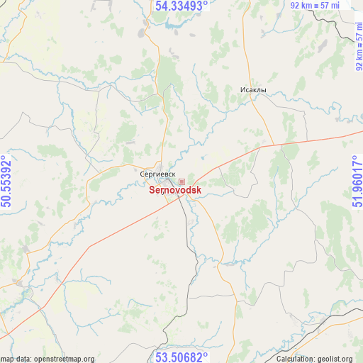
Sernovodsk GPS coordinates[2]
53° 55' 22.548" North, 51° 15' 25.344" East
| Map corner | latitude | longitude |
|---|---|---|
| Upper-left | 54.33493°, | 50.55392° |
| Center: | 53.92293°, | 51.25704° |
| Lower-right: | 53.50682°, | 51.96017° |
| Map W x H: | 92.1×92.1 km | = 57.2×57.2mi |
| max Lat: | 73.50819° ⇑56% North |
| Sernovodsk: | 53.92293° |
| min Lat: | ⇓44% South 41.28413° |
| min Long | Sernovodsk | max Long |
| -179.12198° | 51.25704° | 179.35046° |
| W 63.3%⇐ | ⇒36.7% E |
Elevation
Elevation of Sernovodsk is 92 m = 302 ft, and this is 110.6 m = 363 ft below average elevation for this country.
| Max E: |
2518 m = 8261 ft | 73.8% |
| Avg. | 202.6 m = 665 ft | |
| Sernovodsk | 92 m = 302 ft | |
Min E: |
-28 m = -92 ft | 26.2% |
See also: Russia elevation on elevation.city.
Geographical zone
Sernovodsk is located in North temperate zone (between Tropic of Cancer and the Arctic Circle). Distance of this North polar circle is 1405.5 km =873.3 mi to North.| Distance of | km | miles | from Sernovodsk |
|---|---|---|---|
| North Pole | 4011.4 | 2492.6 | to North |
| Arctic Circle | 1405.5 | 873.3 | to North |
| Tropic Cancer | 3389.7 | 2106.3 | to South |
| Equator | 5995.7 | 3725.6 | to South |


Nearby cities:
15 places around Sernovodsk: (largest is in red/bold)
• Chelno-Vershiny
55.8 km =34.7 mi,  348°
348°
• Isakly
29.5 km =18.3 mi,  37°
37°
• Kamyshla
61.7 km =38.3 mi,  69°
69°
• Kinel’-Cherkassy
52.3 km =32.5 mi,  164°
164°
• Klyavlino
63 km =39.1 mi,  52°
52°
• Koshki
60.5 km =37.6 mi,  301°
301°
• Krasnyy Yar
73.8 km =45.9 mi,  230°
230°
• Krotovka
71.1 km =44.2 mi,  184°
184°
• Nurlat
63.4 km =39.4 mi,  332°
332°
• Otradnyy
61.1 km =38 mi,  174°
174°
• Pokhvistnevo
64.6 km =40.1 mi,  117°
117°
• Shentala
60.4 km =37.5 mi,  14°
14°
• Sukhodol
3.9 km =2.4 mi, 230°
• Surgut
3.5 km =2.2 mi,  273°
273°
• Yelkhovka
64.1 km =39.8 mi,  264°
264°
Sources, notices
• [Note1] Compared only with cities in Russia existing in our database
• [Src1] Map data: © OpenStreetMap contributors (CC-BY-SA)
• [Src2] Other city data from geonames.org with taken over terms of usage.
• [Src3] Geographical zone / Annual Mean Temperature by Robert A. Rohde @ Wikipedia
