Perelyub geodata
Perelyub (Saratovskaya Oblast) is a populated place; located in Russia in Europe/Saratov (GMT+4) time zone. With population of 5,549 people, there are 2420 cities with bigger population in this country. Compared to other cities in Russia, 70% of cities are located further ↑North; 62.5% of cities are located further ←West and 80.6% of cities have higher elevation than Perelyub. Note1


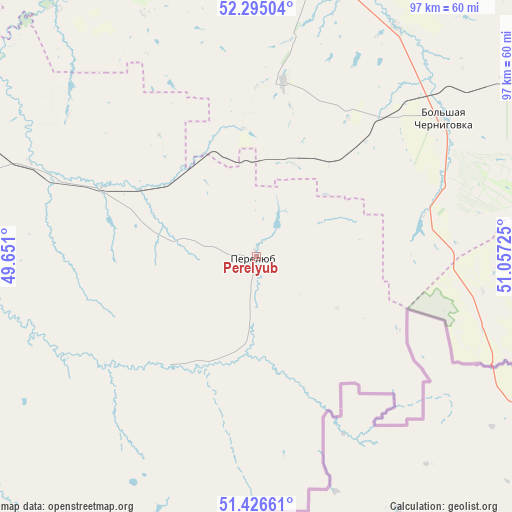
Perelyub GPS coordinates[2]
51° 51' 46.512" North, 50° 21' 14.832" East
| Map corner | latitude | longitude |
|---|---|---|
| Upper-left | 52.29504°, | 49.651° |
| Center: | 51.86292°, | 50.35412° |
| Lower-right: | 51.42661°, | 51.05725° |
| Map W x H: | 96.6×96.6 km | = 60×60mi |
| max Lat: | 73.50819° ⇑70% North |
| Perelyub: | 51.86292° |
| min Lat: | ⇓30% South 41.28413° |
| min Long | Perelyub | max Long |
| -179.12198° | 50.35412° | 179.35046° |
| W 62.5%⇐ | ⇒37.5% E |
Elevation
Elevation of Perelyub is 69 m = 226 ft, and this is 133.6 m = 438 ft below average elevation for this country.
| Max E: |
2518 m = 8261 ft | 80.6% |
| Avg. | 202.6 m = 665 ft | |
| Perelyub | 69 m = 226 ft | |
Min E: |
-28 m = -92 ft | 19.4% |
See also: Russia elevation on elevation.city.
Geographical zone
Perelyub is located in North temperate zone (between Tropic of Cancer and the Arctic Circle). Distance of this North polar circle is 1634.6 km =1015.7 mi to North.| Distance of | km | miles | from Perelyub |
|---|---|---|---|
| North Pole | 4240.4 | 2634.9 | to North |
| Arctic Circle | 1634.6 | 1015.7 | to North |
| Tropic Cancer | 3160.7 | 1964 | to South |
| Equator | 5766.6 | 3583.2 | to South |


Nearby cities:
15 places around Perelyub: (largest is in red/bold)
• Chapayevsk
131.4 km =81.6 mi,  340°
340°
• Dergachi
130.3 km =81 mi,  237°
237°
• Dubovyy Umët
123.9 km =77 mi,  357°
357°
• Gornyy
125.2 km =77.8 mi,  264°
264°
• Ivanteyevka
96.4 km =59.9 mi,  297°
297°
• Khvorostyanka
126.1 km =78.4 mi,  311°
311°
• Krasnoarmeyskoye
97.8 km =60.8 mi,  347°
347°
• Mayskoye
50.5 km =31.4 mi,  334°
334°
• Neftegorsk
118.1 km =73.4 mi,  27°
27°
• Osinki
123.1 km =76.5 mi, 332°
• Pestravka
65.3 km =40.6 mi, 335°
• Pugachev
107.7 km =66.9 mi,  278°
278°
• Roschinskiy
132.5 km =82.3 mi,  4°
4°
• Staryye Ozinki
89.4 km =55.6 mi,  211°
211°
• Utevka
122.6 km =76.2 mi,  19°
19°
Sources, notices
• [Note1] Compared only with cities in Russia existing in our database
• [Src1] Map data: © OpenStreetMap contributors (CC-BY-SA)
• [Src2] Other city data from geonames.org with taken over terms of usage.
• [Src3] Geographical zone / Annual Mean Temperature by Robert A. Rohde @ Wikipedia
