Parfen’yevo geodata
Parfen’yevo (Kostroma Oblast) is a populated place; located in Russia in Europe/Moscow (GMT+3) time zone. With population of 3,200 people, there are 3608 cities with bigger population in this country. Compared to other cities in Russia, 84.7% of cities are located further ↓South; 55% of cities are located further →East and 50.8% of cities have lower elevation than Parfen’yevo. Note1


Parfen’yevo GPS coordinates[2]
58° 29' 2.256" North, 43° 24' 31.536" East
| Map corner | latitude | longitude |
|---|---|---|
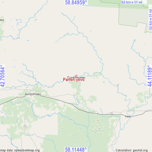
| Upper-left | 58.84959°, | 42.70564° |
| Center: | 58.48396°, | 43.40876° |
| Lower-right: | 58.11448°, | 44.11189° |
| Map W x H: | 81.7×81.7 km | = 50.8×50.8mi |
| max Lat: | 73.50819° ⇑15.3% North |
| Parfen’yevo: | 58.48396° |
| min Lat: | ⇓84.7% South 41.28413° |
| min Long | Parfen’yevo | max Long |
| -179.12198° | 43.40876° | 179.35046° |
| W 45%⇐ | ⇒55% E |
Elevation
Elevation of Parfen’yevo is 146 m = 479 ft, and this is 56.6 m = 186 ft below average elevation for this country.
| Max E: |
2518 m = 8261 ft | 49.2% |
| Avg. | 202.6 m = 665 ft | |
| Parfen’yevo | 146 m = 479 ft | |
Min E: |
-28 m = -92 ft | 50.8% |
See also: Russia elevation on elevation.city.
Geographical zone
Parfen’yevo is located in North temperate zone (between Tropic of Cancer and the Arctic Circle). Distance of this North polar circle is 898.4 km =558.2 mi to North.| Distance of | km | miles | from Parfen’yevo |
|---|---|---|---|
| North Pole | 3504.3 | 2177.5 | to North |
| Arctic Circle | 898.4 | 558.2 | to North |
| Tropic Cancer | 3896.9 | 2421.4 | to South |
| Equator | 6502.8 | 4040.7 | to South |


Nearby cities:
15 places around Parfen’yevo: (largest is in red/bold)
• Antropovo
25.2 km =15.7 mi,  247°
247°
• Buy
108.8 km =67.6 mi,  269°
269°
• Chistyye Bory
104.5 km =64.9 mi,  262°
262°
• Chukhloma
51.6 km =32.1 mi,  305°
305°
• Galich
62.9 km =39.1 mi, 259°
• Georgiyevskoye
97.5 km =60.6 mi,  73°
73°
• Kadyy
78.5 km =48.8 mi,  189°
189°
• Kologriv
65 km =40.4 mi,  54°
54°
• Makar’yev
70.5 km =43.8 mi,  160°
160°
• Manturovo
80.8 km =50.2 mi,  102°
102°
• Neya
33.9 km =21.1 mi,  127°
127°
• Ostrovskoye
101.8 km =63.3 mi,  222°
222°
• Soligalich
92.6 km =57.5 mi,  315°
315°
• Susanino
112.3 km =69.8 mi, 250°
• Vetluzhskiy
120.1 km =74.6 mi,  94°
94°
Sources, notices
• [Note1] Compared only with cities in Russia existing in our database
• [Src1] Map data: © OpenStreetMap contributors (CC-BY-SA)
• [Src2] Other city data from geonames.org with taken over terms of usage.
• [Src3] Geographical zone / Annual Mean Temperature by Robert A. Rohde @ Wikipedia
