Georgiyevskoye geodata
Georgiyevskoye (Kostroma Oblast) is a populated place; located in Russia in Europe/Moscow (GMT+3) time zone. With population of 2,800 people, there are 3860 cities with bigger population in this country. Compared to other cities in Russia, 85.6% of cities are located further ↓South; 50.1% of cities are located further ←West and 51.9% of cities have lower elevation than Georgiyevskoye. Note1


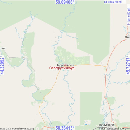
Georgiyevskoye GPS coordinates[2]
58° 43' 51.636" North, 45° 1' 26.544" East
| Map corner | latitude | longitude |
|---|---|---|
| Upper-left | 59.09406°, | 44.32092° |
| Center: | 58.73101°, | 45.02404° |
| Lower-right: | 58.36413°, | 45.72717° |
| Map W x H: | 81.2×81.2 km | = 50.5×50.5mi |
| max Lat: | 73.50819° ⇑14.4% North |
| Georgiyevskoye: | 58.73101° |
| min Lat: | ⇓85.6% South 41.28413° |
| min Long | Georgiyevskoye | max Long |
| -179.12198° | 45.02404° | 179.35046° |
| W 50.1%⇐ | ⇒49.9% E |
Elevation
Elevation of Georgiyevskoye is 149 m = 489 ft, and this is 53.6 m = 176 ft below average elevation for this country.
| Max E: |
2518 m = 8261 ft | 48.1% |
| Avg. | 202.6 m = 665 ft | |
| Georgiyevskoye | 149 m = 489 ft | |
Min E: |
-28 m = -92 ft | 51.9% |
See also: Russia elevation on elevation.city.
Geographical zone
Georgiyevskoye is located in North temperate zone (between Tropic of Cancer and the Arctic Circle). Distance of this North polar circle is 870.9 km =541.2 mi to North.| Distance of | km | miles | from Georgiyevskoye |
|---|---|---|---|
| North Pole | 3476.8 | 2160.4 | to North |
| Arctic Circle | 870.9 | 541.2 | to North |
| Tropic Cancer | 3924.4 | 2438.5 | to South |
| Equator | 6530.3 | 4057.7 | to South |


Nearby cities:
15 places around Georgiyevskoye: (largest is in red/bold)
• Bogovarovo
118.3 km =73.5 mi,  76°
76°
• Kologriv
42.1 km =26.2 mi,  284°
284°
• Makar’yev
118 km =73.3 mi,  217°
217°
• Manturovo
47.2 km =29.3 mi,  198°
198°
• Neya
82.7 km =51.4 mi,  234°
234°
• Nikol’sk
92.8 km =57.7 mi,  15°
15°
• Parfen’yevo
97.5 km =60.6 mi,  253°
253°
• Pavino
77 km =47.8 mi,  56°
56°
• Ponazyrevo
85.6 km =53.2 mi,  118°
118°
• Pyshchug
43.3 km =26.9 mi,  66°
66°
• Shar’ya
49.3 km =30.6 mi,  144°
144°
• Syava
109.9 km =68.3 mi, 136°
• Vetluga
106.9 km =66.4 mi,  155°
155°
• Vetluzhskiy
45.7 km =28.4 mi,  145°
145°
• Vokhma
102.2 km =63.5 mi, 77°
Sources, notices
• [Note1] Compared only with cities in Russia existing in our database
• [Src1] Map data: © OpenStreetMap contributors (CC-BY-SA)
• [Src2] Other city data from geonames.org with taken over terms of usage.
• [Src3] Geographical zone / Annual Mean Temperature by Robert A. Rohde @ Wikipedia
