Manturovo geodata
Manturovo (Kostroma Oblast) is a populated place; located in Russia in Europe/Moscow (GMT+3) time zone. With population of 18,817 people, there are 915 cities with bigger population in this country. Compared to other cities in Russia, 84% of cities are located further ↓South; 50.7% of cities are located further →East and 57.3% of cities have higher elevation than Manturovo. Note1


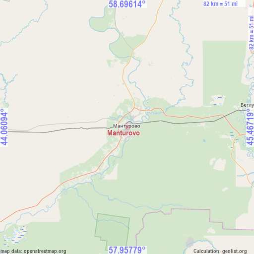
Manturovo GPS coordinates[2]
58° 19' 44.004" North, 44° 45' 50.616" East
| Map corner | latitude | longitude |
|---|---|---|
| Upper-left | 58.69614°, | 44.06094° |
| Center: | 58.32889°, | 44.76406° |
| Lower-right: | 57.95779°, | 45.46719° |
| Map W x H: | 82.1×82.1 km | = 51×51mi |
| max Lat: | 73.50819° ⇑16% North |
| Manturovo: | 58.32889° |
| min Lat: | ⇓84% South 41.28413° |
| min Long | Manturovo | max Long |
| -179.12198° | 44.76406° | 179.35046° |
| W 49.3%⇐ | ⇒50.7% E |
Elevation
Elevation of Manturovo is 130 m = 427 ft, and this is 72.6 m = 238 ft below average elevation for this country.
| Max E: |
2518 m = 8261 ft | 57.3% |
| Avg. | 202.6 m = 665 ft | |
| Manturovo | 130 m = 427 ft | |
Min E: |
-28 m = -92 ft | 42.7% |
See also: Russia elevation on elevation.city.
Geographical zone
Manturovo is located in North temperate zone (between Tropic of Cancer and the Arctic Circle). Distance of this North polar circle is 915.6 km =568.9 mi to North.| Distance of | km | miles | from Manturovo |
|---|---|---|---|
| North Pole | 3521.5 | 2188.2 | to North |
| Arctic Circle | 915.6 | 568.9 | to North |
| Tropic Cancer | 3879.6 | 2410.7 | to South |
| Equator | 6485.6 | 4030 | to South |


Nearby cities:
15 places around Manturovo: (largest is in red/bold)
• Antropovo
102.8 km =63.9 mi,  274°
274°
• Georgiyevskoye
47.2 km =29.3 mi,  18°
18°
• Kadyy
110.5 km =68.7 mi,  236°
236°
• Kologriv
61.2 km =38 mi,  334°
334°
• Makar’yev
74.9 km =46.5 mi,  228°
228°
• Neya
52.4 km =32.6 mi, 266°
• Parfen’yevo
80.8 km =50.2 mi,  282°
282°
• Ponazyrevo
90.5 km =56.2 mi,  87°
87°
• Pyshchug
82.9 km =51.5 mi,  41°
41°
• Shar’ya
44.1 km =27.4 mi,  84°
84°
• Syava
97.8 km =60.8 mi,  110°
110°
• Uren’
114.4 km =71.1 mi,  148°
148°
• Varnavino
104.7 km =65.1 mi,  169°
169°
• Vetluga
79.6 km =49.5 mi,  131°
131°
• Vetluzhskiy
41.5 km =25.8 mi, 80°
In other languages:
- In Spanish: Mánturovo
- In France: Mantourovo
- In German: Manturowo
- In Russian: Мантурово
- In Chinese: 曼圖羅沃
Sources, notices
• [Note1] Compared only with cities in Russia existing in our database
• [Src1] Map data: © OpenStreetMap contributors (CC-BY-SA)
• [Src2] Other city data from geonames.org with taken over terms of usage.
• [Src3] Geographical zone / Annual Mean Temperature by Robert A. Rohde @ Wikipedia
