Kuzhorskaya geodata
Kuzhorskaya (Adygeya Republic) is a populated place; located in Russia in Europe/Moscow (GMT+3) time zone. With population of 3,556 people, there are 3370 cities with bigger population in this country. Compared to other cities in Russia, 88.9% of cities are located further ↑North; 66% of cities are located further →East and 76.9% of cities have lower elevation than Kuzhorskaya. Note1


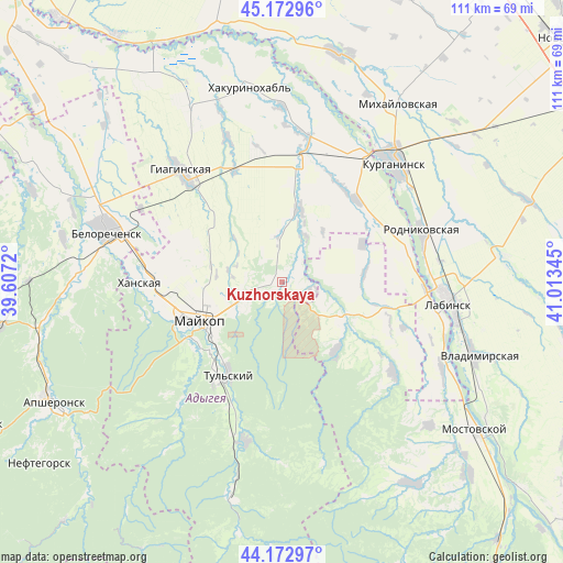
Kuzhorskaya GPS coordinates[2]
44° 40' 30.432" North, 40° 18' 37.152" East
| Map corner | latitude | longitude |
|---|---|---|
| Upper-left | 45.17296°, | 39.6072° |
| Center: | 44.67512°, | 40.31032° |
| Lower-right: | 44.17297°, | 41.01345° |
| Map W x H: | 111.2×111.2 km | = 69.1×69.1mi |
| max Lat: | 73.50819° ⇑88.9% North |
| Kuzhorskaya: | 44.67512° |
| min Lat: | ⇓11.1% South 41.28413° |
| min Long | Kuzhorskaya | max Long |
| -179.12198° | 40.31032° | 179.35046° |
| W 34%⇐ | ⇒66% E |
Elevation
Elevation of Kuzhorskaya is 226 m = 741 ft, and this is 23.4 m = 77 ft above average elevation for this country.
| Max E: |
2518 m = 8261 ft | 23.1% |
| Kuzhorskaya | 226 m 741 ft | |
| Avg. | 202.6 m = 665 ft | |
Min E: |
-28 m = -92 ft | 76.9% |
See also: Russia elevation on elevation.city.
Geographical zone
Kuzhorskaya is located in North temperate zone (between Tropic of Cancer and the Arctic Circle). Distance of this Northern Tropic circle is 2361.5 km =1467.4 mi to South.| Distance of | km | miles | from Kuzhorskaya |
|---|---|---|---|
| North Pole | 5039.7 | 3131.5 | to North |
| Arctic Circle | 2433.8 | 1512.3 | to North |
| Tropic Cancer | 2361.5 | 1467.4 | to South |
| Equator | 4967.4 | 3086.6 | to South |


Nearby cities:
15 places around Kuzhorskaya: (largest is in red/bold)
• Abadzekhskaya
32.1 km =19.9 mi,  192°
192°
• Belorechensk
35.7 km =22.2 mi,  287°
287°
• Blechepsin
22 km =13.7 mi,  42°
42°
• Dondukovskaya
23.4 km =14.5 mi,  10°
10°
• Giaginskaya
28 km =17.4 mi,  317°
317°
• Khanskaya
27.6 km =17.1 mi,  270°
270°
• Koshekhabl’
29.4 km =18.3 mi,  32°
32°
• Kurganinsk
32.2 km =20 mi, 44°
• Labinsk
33.9 km =21.1 mi,  97°
97°
• Maykop
17.8 km =11.1 mi,  245°
245°
• Natyrbovo
25.7 km =16 mi,  76°
76°
• Rodnikovskaya
29.8 km =18.5 mi,  70°
70°
• Tul’skiy
20.8 km =12.9 mi,  210°
210°
• Yaroslavskaya
14.1 km =8.8 mi,  120°
120°
• Yuzhnyy
34.5 km =21.4 mi,  278°
278°
Sources, notices
• [Note1] Compared only with cities in Russia existing in our database
• [Src1] Map data: © OpenStreetMap contributors (CC-BY-SA)
• [Src2] Other city data from geonames.org with taken over terms of usage.
• [Src3] Geographical zone / Annual Mean Temperature by Robert A. Rohde @ Wikipedia
