Mrakovo geodata
Mrakovo (Bashkortostan Republic) is a populated place; located in Russia in Asia/Yekaterinburg (GMT+5) time zone. With population of 8,394 people, there are 1738 cities with bigger population in this country. Compared to other cities in Russia, 64.7% of cities are located further ↑North; 68.2% of cities are located further ←West and 77.7% of cities have lower elevation than Mrakovo. Note1


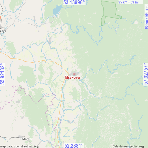
Mrakovo GPS coordinates[2]
52° 42' 57.996" North, 56° 37' 27.984" East
| Map corner | latitude | longitude |
|---|---|---|
| Upper-left | 53.13996°, | 55.92132° |
| Center: | 52.71611°, | 56.62444° |
| Lower-right: | 52.2881°, | 57.32757° |
| Map W x H: | 94.7×94.7 km | = 58.8×58.8mi |
| max Lat: | 73.50819° ⇑64.7% North |
| Mrakovo: | 52.71611° |
| min Lat: | ⇓35.3% South 41.28413° |
| min Long | Mrakovo | max Long |
| -179.12198° | 56.62444° | 179.35046° |
| W 68.2%⇐ | ⇒31.8% E |
Elevation
Elevation of Mrakovo is 231 m = 758 ft, and this is 28.4 m = 93 ft above average elevation for this country.
| Max E: |
2518 m = 8261 ft | 22.3% |
| Mrakovo | 231 m 758 ft | |
| Avg. | 202.6 m = 665 ft | |
Min E: |
-28 m = -92 ft | 77.7% |
See also: Russia elevation on elevation.city.
Geographical zone
Mrakovo is located in North temperate zone (between Tropic of Cancer and the Arctic Circle). Distance of this North polar circle is 1539.7 km =956.7 mi to North.| Distance of | km | miles | from Mrakovo |
|---|---|---|---|
| North Pole | 4145.6 | 2576 | to North |
| Arctic Circle | 1539.7 | 956.7 | to North |
| Tropic Cancer | 3255.6 | 2022.9 | to South |
| Equator | 5861.5 | 3642.2 | to South |


Nearby cities:
15 places around Mrakovo: (largest is in red/bold)
• Galiakberovo
68.1 km =42.3 mi,  25°
25°
• Ishimbay
90.9 km =56.5 mi,  334°
334°
• Isyangulovo
59 km =36.7 mi,  182°
182°
• Kumertau
56.9 km =35.4 mi,  275°
275°
• Matveyevka
69.7 km =43.3 mi,  205°
205°
• Mayachnyy
63.4 km =39.4 mi,  266°
266°
• Meleuz
54.1 km =33.6 mi,  300°
300°
• Salavat
88.3 km =54.9 mi, 327°
• Starosubkhangulovo
69.7 km =43.3 mi,  51°
51°
• Tyul’gan
52 km =32.3 mi,  216°
216°
• Voskresenskoye
55.5 km =34.5 mi,  324°
324°
• Yermolayevo
55.5 km =34.5 mi, 270°
• Yumaguzino
26 km =16.2 mi, 323°
• Zilair
77 km =47.8 mi,  134°
134°
• Zirgan
73.5 km =45.7 mi, 319°
Sources, notices
• [Note1] Compared only with cities in Russia existing in our database
• [Src1] Map data: © OpenStreetMap contributors (CC-BY-SA)
• [Src2] Other city data from geonames.org with taken over terms of usage.
• [Src3] Geographical zone / Annual Mean Temperature by Robert A. Rohde @ Wikipedia
