Chertkovo geodata
Chertkovo (Rostov) is a seat of a second-order administrative division; located in Russia in Europe/Moscow (GMT+3) time zone. With population of 11,000 people, there are 1371 cities with bigger population in this country. Compared to other cities in Russia, 78.6% of cities are located further ↑North; 66.8% of cities are located further →East and 50.2% of cities have higher elevation than Chertkovo. Note1


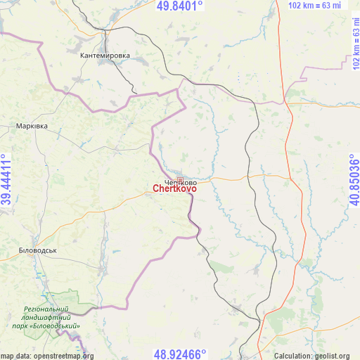
Chertkovo GPS coordinates[2]
49° 23' 4.236" North, 40° 8' 50.028" East
| Map corner | latitude | longitude |
|---|---|---|
| Upper-left | 49.8401°, | 39.44411° |
| Center: | 49.38451°, | 40.14723° |
| Lower-right: | 48.92466°, | 40.85036° |
| Map W x H: | 101.8×101.8 km | = 63.3×63.3mi |
| max Lat: | 73.50819° ⇑78.6% North |
| Chertkovo: | 49.38451° |
| min Lat: | ⇓21.4% South 41.28413° |
| min Long | Chertkovo | max Long |
| -179.12198° | 40.14723° | 179.35046° |
| W 33.2%⇐ | ⇒66.8% E |
Elevation
Elevation of Chertkovo is 144 m = 472 ft, and this is 58.6 m = 192 ft below average elevation for this country.
| Max E: |
2518 m = 8261 ft | 50.2% |
| Avg. | 202.6 m = 665 ft | |
| Chertkovo | 144 m = 472 ft | |
Min E: |
-28 m = -92 ft | 49.8% |
See also: Russia elevation on elevation.city.
Geographical zone
Chertkovo is located in North temperate zone (between Tropic of Cancer and the Arctic Circle). Distance of this North polar circle is 1910.1 km =1186.9 mi to North.| Distance of | km | miles | from Chertkovo |
|---|---|---|---|
| North Pole | 4516 | 2806.1 | to North |
| Arctic Circle | 1910.1 | 1186.9 | to North |
| Tropic Cancer | 2885.1 | 1792.7 | to South |
| Equator | 5491 | 3411.9 | to South |


Nearby cities:
15 places around Chertkovo: (largest is in red/bold)
• Boguchar
67.7 km =42.1 mi,  25°
25°
• Glubokiy
96.3 km =59.8 mi,  171°
171°
• Kantemirovka
41.6 km =25.8 mi,  330°
330°
• Kashary
73.2 km =45.5 mi,  121°
121°
• Kazanskaya
85.2 km =52.9 mi,  57°
57°
• Krasnovka
63.2 km =39.3 mi,  183°
183°
• Masalovka
109.4 km =68 mi, 175°
• Millerovo
54.5 km =33.9 mi,  160°
160°
• Mitrofanovka
72.9 km =45.3 mi, 333°
• Nizhniy Mamon
93.6 km =58.2 mi,  16°
16°
• Rossosh’
99.6 km =61.9 mi,  335°
335°
• Staraya Stanitsa
116 km =72.1 mi, 174°
• Tarasovskiy
74.7 km =46.4 mi, 167°
• Verkhniy Mamon
88.3 km =54.9 mi,  11°
11°
• Zabolotovka
115.9 km =72 mi, 328°
Sources, notices
• [Note1] Compared only with cities in Russia existing in our database
• [Src1] Map data: © OpenStreetMap contributors (CC-BY-SA)
• [Src2] Other city data from geonames.org with taken over terms of usage.
• [Src3] Geographical zone / Annual Mean Temperature by Robert A. Rohde @ Wikipedia
