Mayskiy geodata
Mayskiy (Belgorod Oblast) is a populated place; located in Russia in Europe/Moscow (GMT+3) time zone. With population of 7,537 people, there are 1896 cities with bigger population in this country. Compared to other cities in Russia, 76.6% of cities are located further ↑North; 86.4% of cities are located further →East and 64.3% of cities have lower elevation than Mayskiy. Note1


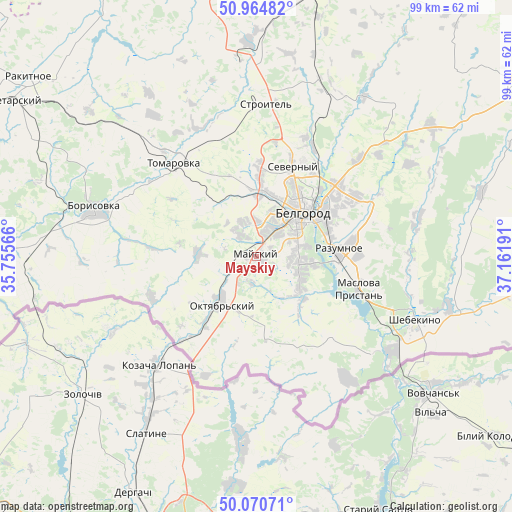
Mayskiy GPS coordinates[2]
50° 31' 11.568" North, 36° 27' 31.608" East
| Map corner | latitude | longitude |
|---|---|---|
| Upper-left | 50.96482°, | 35.75566° |
| Center: | 50.51988°, | 36.45878° |
| Lower-right: | 50.07071°, | 37.16191° |
| Map W x H: | 99.4×99.4 km | = 61.8×61.8mi |
| max Lat: | 73.50819° ⇑76.6% North |
| Mayskiy: | 50.51988° |
| min Lat: | ⇓23.4% South 41.28413° |
| min Long | Mayskiy | max Long |
| -179.12198° | 36.45878° | 179.35046° |
| W 13.6%⇐ | ⇒86.4% E |
Elevation
Elevation of Mayskiy is 180 m = 591 ft, and this is 22.6 m = 74 ft below average elevation for this country.
| Max E: |
2518 m = 8261 ft | 35.7% |
| Avg. | 202.6 m = 665 ft | |
| Mayskiy | 180 m = 591 ft | |
Min E: |
-28 m = -92 ft | 64.3% |
See also: Russia elevation on elevation.city.
Geographical zone
Mayskiy is located in North temperate zone (between Tropic of Cancer and the Arctic Circle). Distance of this North polar circle is 1783.9 km =1108.5 mi to North.| Distance of | km | miles | from Mayskiy |
|---|---|---|---|
| North Pole | 4389.8 | 2727.7 | to North |
| Arctic Circle | 1783.9 | 1108.5 | to North |
| Tropic Cancer | 3011.4 | 1871.2 | to South |
| Equator | 5617.3 | 3490.4 | to South |


Nearby cities:
15 places around Mayskiy: (largest is in red/bold)
• Belgorod
13.2 km =8.2 mi,  40°
40°
• Bessonovka
11.2 km =7 mi,  273°
273°
• Borisovka
32.6 km =20.3 mi,  286°
286°
• Golovchino
46.8 km =29.1 mi, 271°
• Gorod Shebekino
34.4 km =21.4 mi,  109°
109°
• Grayvoron
55.5 km =34.5 mi, 265°
• Maslova Pristan’
19.8 km =12.3 mi, 110°
• Novaya Tavolzhanka
32.3 km =20.1 mi,  125°
125°
• Rakitnoye
55.6 km =34.5 mi,  309°
309°
• Razumnoye
16 km =9.9 mi,  84°
84°
• Severnyy
18.7 km =11.6 mi,  20°
20°
• Shebekino
34.4 km =21.4 mi, 110°
• Stroitel’
29.6 km =18.4 mi,  3°
3°
• Tomarovka
24.2 km =15 mi,  318°
318°
• Yakovlevo
37.9 km =23.5 mi,  358°
358°
Sources, notices
• [Note1] Compared only with cities in Russia existing in our database
• [Src1] Map data: © OpenStreetMap contributors (CC-BY-SA)
• [Src2] Other city data from geonames.org with taken over terms of usage.
• [Src3] Geographical zone / Annual Mean Temperature by Robert A. Rohde @ Wikipedia
