Maslova Pristan’ geodata
Maslova Pristan’ (Belgorod Oblast) is a populated place; located in Russia in Europe/Moscow (GMT+3) time zone. With population of 5,669 people, there are 2374 cities with bigger population in this country. Compared to other cities in Russia, 76.7% of cities are located further ↑North; 85.6% of cities are located further →East and 63% of cities have higher elevation than Maslova Pristan’. Note1


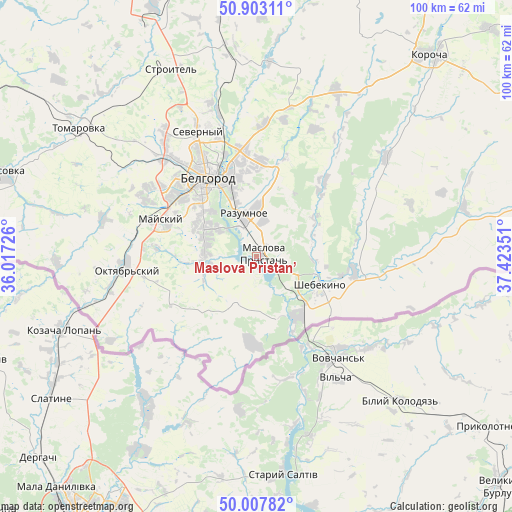
Maslova Pristan’ GPS coordinates[2]
50° 27' 27.288" North, 36° 43' 13.368" East
| Map corner | latitude | longitude |
|---|---|---|
| Upper-left | 50.90311°, | 36.01726° |
| Center: | 50.45758°, | 36.72038° |
| Lower-right: | 50.00782°, | 37.42351° |
| Map W x H: | 99.5×99.5 km | = 61.8×61.8mi |
| max Lat: | 73.50819° ⇑76.7% North |
| Maslova Pristan’: | 50.45758° |
| min Lat: | ⇓23.3% South 41.28413° |
| min Long | Maslova Pristan | max Long |
| -179.12198° | 36.72038° | 179.35046° |
| W 14.4%⇐ | ⇒85.6% E |
Elevation
Elevation of Maslova Pristan’ is 118 m = 387 ft, and this is 84.6 m = 278 ft below average elevation for this country.
| Max E: |
2518 m = 8261 ft | 63% |
| Avg. | 202.6 m = 665 ft | |
| Maslova Pristan’ | 118 m = 387 ft | |
Min E: |
-28 m = -92 ft | 37% |
See also: Russia elevation on elevation.city.
Geographical zone
Maslova Pristan’ is located in North temperate zone (between Tropic of Cancer and the Arctic Circle). Distance of this North polar circle is 1790.8 km =1112.8 mi to North.| Distance of | km | miles | from Maslova Pristan’ |
|---|---|---|---|
| North Pole | 4396.7 | 2732 | to North |
| Arctic Circle | 1790.8 | 1112.8 | to North |
| Tropic Cancer | 3004.4 | 1866.8 | to South |
| Equator | 5610.4 | 3486.1 | to South |


Nearby cities:
15 places around Maslova Pristan’: (largest is in red/bold)
• Bekhteyevka
52.4 km =32.6 mi,  42°
42°
• Belgorod
19.7 km =12.2 mi,  329°
329°
• Bessonovka
30.6 km =19 mi,  284°
284°
• Borisovka
52.3 km =32.5 mi,  287°
287°
• Gorod Shebekino
14.6 km =9.1 mi,  108°
108°
• Korocha
51.4 km =31.9 mi, 39°
• Mayskiy
19.8 km =12.3 mi, 290°
• Novaya Tavolzhanka
14.1 km =8.8 mi,  146°
146°
• Prokhorovka
64.5 km =40.1 mi,  0°
0°
• Razumnoye
8.9 km =5.5 mi,  343°
343°
• Severnyy
27.1 km =16.8 mi, 334°
• Shebekino
14.7 km =9.1 mi, 111°
• Stroitel’
40.1 km =24.9 mi, 335°
• Tomarovka
42.6 km =26.5 mi,  306°
306°
• Yakovlevo
48.7 km =30.3 mi, 336°
Sources, notices
• [Note1] Compared only with cities in Russia existing in our database
• [Src1] Map data: © OpenStreetMap contributors (CC-BY-SA)
• [Src2] Other city data from geonames.org with taken over terms of usage.
• [Src3] Geographical zone / Annual Mean Temperature by Robert A. Rohde @ Wikipedia
