Prokhladnyy geodata
Prokhladnyy (Kabardino-Balkariya Republic) is a seat of a second-order administrative division; located in Russia in Europe/Moscow (GMT+3) time zone. With population of 60,800 people, there are 347 cities with bigger population in this country. Compared to other cities in Russia, 92.7% of cities are located further ↑North; 52.8% of cities are located further →East and 73% of cities have lower elevation than Prokhladnyy. Note1


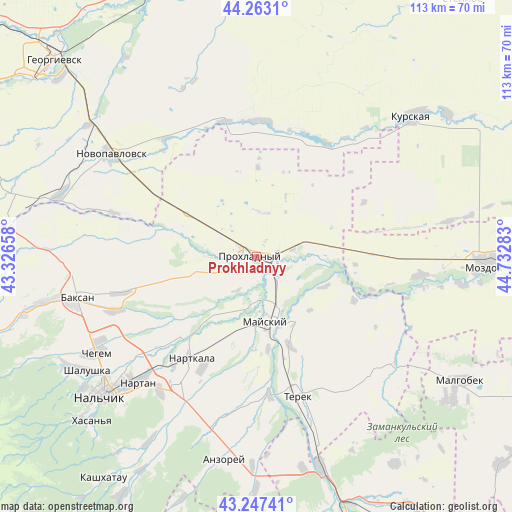
Prokhladnyy GPS coordinates[2]
43° 45' 26.676" North, 44° 1' 46.92" East
| Map corner | latitude | longitude |
|---|---|---|
| Upper-left | 44.2631°, | 43.32658° |
| Center: | 43.75741°, | 44.0297° |
| Lower-right: | 43.24741°, | 44.73283° |
| Map W x H: | 112.9×112.9 km | = 70.2×70.2mi |
| max Lat: | 73.50819° ⇑92.7% North |
| Prokhladnyy: | 43.75741° |
| min Lat: | ⇓7.3% South 41.28413° |
| min Long | Prokhladnyy | max Long |
| -179.12198° | 44.0297° | 179.35046° |
| W 47.2%⇐ | ⇒52.8% E |
Elevation
Elevation of Prokhladnyy is 208 m = 682 ft, and this is 5.4 m = 18 ft above average elevation for this country.
| Max E: |
2518 m = 8261 ft | 27% |
| Prokhladnyy | 208 m 682 ft | |
| Avg. | 202.6 m = 665 ft | |
Min E: |
-28 m = -92 ft | 73% |
See also: Prokhladnyy elevation on elevation.city.
Geographical zone
Prokhladnyy is located in North temperate zone (between Tropic of Cancer and the Arctic Circle). Distance of this Northern Tropic circle is 2259.4 km =1403.9 mi to South.| Distance of | km | miles | from Prokhladnyy |
|---|---|---|---|
| North Pole | 5141.7 | 3194.9 | to North |
| Arctic Circle | 2535.8 | 1575.7 | to North |
| Tropic Cancer | 2259.4 | 1403.9 | to South |
| Equator | 4865.4 | 3023.2 | to South |


Nearby cities:
15 places around Prokhladnyy: (largest is in red/bold)
• Altud
13.7 km =8.5 mi,  253°
253°
• Baksanenok
31.1 km =19.3 mi,  255°
255°
• Deyskoye
33.1 km =20.6 mi,  161°
161°
• Germenchik
27.9 km =17.3 mi,  229°
229°
• Kakhun
26.8 km =16.7 mi,  207°
207°
• Karagach
21.1 km =13.1 mi,  284°
284°
• Kishpek
33.3 km =20.7 mi, 249°
• Kotlyarevskaya
20.6 km =12.8 mi,  172°
172°
• Mayskiy
12.9 km =8 mi,  176°
176°
• Nartkala
26.5 km =16.5 mi, 212°
• Nizhniy Cherek
28.7 km =17.8 mi,  198°
198°
• Primalkinskoye
2.1 km =1.3 mi,  235°
235°
• Soldatskaya
18.4 km =11.4 mi,  291°
291°
• Sovetskaya
30 km =18.6 mi,  3°
3°
• Terek
31.7 km =19.7 mi, 164°
Sources, notices
• [Note1] Compared only with cities in Russia existing in our database
• [Src1] Map data: © OpenStreetMap contributors (CC-BY-SA)
• [Src2] Other city data from geonames.org with taken over terms of usage.
• [Src3] Geographical zone / Annual Mean Temperature by Robert A. Rohde @ Wikipedia
