Altud geodata
Altud (Kabardino-Balkariya Republic) is a populated place; located in Russia in Europe/Moscow (GMT+3) time zone. With population of 5,578 people, there are 2409 cities with bigger population in this country. Compared to other cities in Russia, 92.9% of cities are located further ↑North; 53.3% of cities are located further →East and 78.4% of cities have lower elevation than Altud. Note1


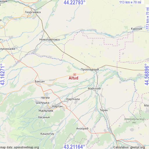
Altud GPS coordinates[2]
43° 43' 18.984" North, 43° 51' 56.988" East
| Map corner | latitude | longitude |
|---|---|---|
| Upper-left | 44.22793°, | 43.16271° |
| Center: | 43.72194°, | 43.86583° |
| Lower-right: | 43.21164°, | 44.56896° |
| Map W x H: | 113×113 km | = 70.2×70.2mi |
| max Lat: | 73.50819° ⇑92.9% North |
| Altud: | 43.72194° |
| min Lat: | ⇓7.1% South 41.28413° |
| min Long | Altud | max Long |
| -179.12198° | 43.86583° | 179.35046° |
| W 46.7%⇐ | ⇒53.3% E |
Elevation
Elevation of Altud is 237 m = 778 ft, and this is 34.4 m = 113 ft above average elevation for this country.
| Max E: |
2518 m = 8261 ft | 21.6% |
| Altud | 237 m 778 ft | |
| Avg. | 202.6 m = 665 ft | |
Min E: |
-28 m = -92 ft | 78.4% |
See also: Russia elevation on elevation.city.
Geographical zone
Altud is located in North temperate zone (between Tropic of Cancer and the Arctic Circle). Distance of this Northern Tropic circle is 2255.5 km =1401.5 mi to South.| Distance of | km | miles | from Altud |
|---|---|---|---|
| North Pole | 5145.6 | 3197.3 | to North |
| Arctic Circle | 2539.8 | 1578.2 | to North |
| Tropic Cancer | 2255.5 | 1401.5 | to South |
| Equator | 4861.4 | 3020.7 | to South |


Nearby cities:
15 places around Altud: (largest is in red/bold)
• Baksan
26.7 km =16.6 mi,  261°
261°
• Baksanenok
17.3 km =10.7 mi, 258°
• Chegem Vtoroy
25.6 km =15.9 mi,  236°
236°
• Germenchik
16.3 km =10.1 mi,  209°
209°
• Kakhun
19.9 km =12.4 mi,  177°
177°
• Karagach
11.8 km =7.3 mi,  321°
321°
• Kishpek
19.6 km =12.2 mi,  247°
247°
• Kotlyarevskaya
22.8 km =14.2 mi,  136°
136°
• Mayskiy
16.5 km =10.3 mi,  122°
122°
• Nartkala
18.3 km =11.4 mi, 183°
• Nizhniy Cherek
23.5 km =14.6 mi,  170°
170°
• Primalkinskoye
11.8 km =7.3 mi,  76°
76°
• Prokhladnyy
13.7 km =8.5 mi,  73°
73°
• Soldatskaya
11.4 km =7.1 mi,  339°
339°
• Staropavlovskaya
23.4 km =14.5 mi,  307°
307°
Sources, notices
• [Note1] Compared only with cities in Russia existing in our database
• [Src1] Map data: © OpenStreetMap contributors (CC-BY-SA)
• [Src2] Other city data from geonames.org with taken over terms of usage.
• [Src3] Geographical zone / Annual Mean Temperature by Robert A. Rohde @ Wikipedia
