Kiknur geodata
Kiknur (Kirov) is a populated place; located in Russia in Europe/Kirov (GMT+3) time zone. With population of 5,246 people, there are 2534 cities with bigger population in this country. Compared to other cities in Russia, 79% of cities are located further ↓South; 56.5% of cities are located further ←West and 65.3% of cities have higher elevation than Kiknur. Note1


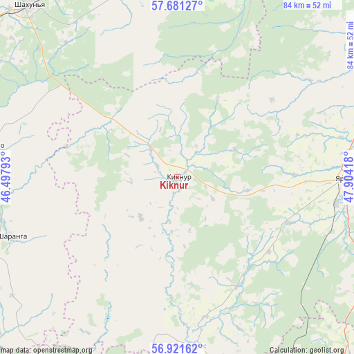
Kiknur GPS coordinates[2]
57° 18' 12.276" North, 47° 12' 3.78" East
| Map corner | latitude | longitude |
|---|---|---|
| Upper-left | 57.68127°, | 46.49793° |
| Center: | 57.30341°, | 47.20105° |
| Lower-right: | 56.92162°, | 47.90418° |
| Map W x H: | 84.5×84.5 km | = 52.5×52.5mi |
| max Lat: | 73.50819° ⇑21% North |
| Kiknur: | 57.30341° |
| min Lat: | ⇓79% South 41.28413° |
| min Long | Kiknur | max Long |
| -179.12198° | 47.20105° | 179.35046° |
| W 56.5%⇐ | ⇒43.5% E |
Elevation
Elevation of Kiknur is 113 m = 371 ft, and this is 89.6 m = 294 ft below average elevation for this country.
| Max E: |
2518 m = 8261 ft | 65.3% |
| Avg. | 202.6 m = 665 ft | |
| Kiknur | 113 m = 371 ft | |
Min E: |
-28 m = -92 ft | 34.7% |
See also: Russia elevation on elevation.city.
Geographical zone
Kiknur is located in North temperate zone (between Tropic of Cancer and the Arctic Circle). Distance of this North polar circle is 1029.6 km =639.8 mi to North.| Distance of | km | miles | from Kiknur |
|---|---|---|---|
| North Pole | 3635.5 | 2259 | to North |
| Arctic Circle | 1029.6 | 639.8 | to North |
| Tropic Cancer | 3765.6 | 2339.8 | to South |
| Equator | 6371.5 | 3959.1 | to South |


Nearby cities:
15 places around Kiknur: (largest is in red/bold)
• Arbazh
78.2 km =48.6 mi,  57°
57°
• Ar’ya
76.8 km =47.7 mi,  285°
285°
• Kilemary
61.8 km =38.4 mi,  199°
199°
• Orshanka
60 km =37.3 mi,  135°
135°
• Pizhma
62.6 km =38.9 mi,  355°
355°
• Prudy
63.2 km =39.3 mi,  298°
298°
• Sanchursk
40.4 km =25.1 mi,  175°
175°
• Shakhun’ya
54.4 km =33.8 mi,  319°
319°
• Sharanga
42.2 km =26.2 mi,  250°
250°
• Shaygino
55.4 km =34.4 mi,  338°
338°
• Tonkino
45 km =28 mi,  279°
279°
• Tonshayevo
49.4 km =30.7 mi,  346°
346°
• Tuzha
55.4 km =34.4 mi,  52°
52°
• Vakhtan
79.7 km =49.5 mi, 337°
• Yaransk
41.1 km =25.5 mi,  90°
90°
Sources, notices
• [Note1] Compared only with cities in Russia existing in our database
• [Src1] Map data: © OpenStreetMap contributors (CC-BY-SA)
• [Src2] Other city data from geonames.org with taken over terms of usage.
• [Src3] Geographical zone / Annual Mean Temperature by Robert A. Rohde @ Wikipedia
