Tonshayevo geodata
Tonshayevo (Nizhny Novgorod Oblast) is a populated place; located in Russia in Europe/Moscow (GMT+3) time zone. With population of 4,574 people, there are 2838 cities with bigger population in this country. Compared to other cities in Russia, 81.2% of cities are located further ↓South; 56% of cities are located further ←West and 52.6% of cities have higher elevation than Tonshayevo. Note1


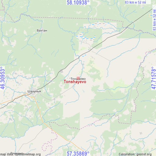
Tonshayevo GPS coordinates[2]
57° 44' 9.528" North, 47° 0' 45.54" East
| Map corner | latitude | longitude |
|---|---|---|
| Upper-left | 58.10938°, | 46.30953° |
| Center: | 57.73598°, | 47.01265° |
| Lower-right: | 57.35869°, | 47.71578° |
| Map W x H: | 83.5×83.5 km | = 51.9×51.9mi |
| max Lat: | 73.50819° ⇑18.8% North |
| Tonshayevo: | 57.73598° |
| min Lat: | ⇓81.2% South 41.28413° |
| min Long | Tonshayevo | max Long |
| -179.12198° | 47.01265° | 179.35046° |
| W 56%⇐ | ⇒44% E |
Elevation
Elevation of Tonshayevo is 139 m = 456 ft, and this is 63.6 m = 209 ft below average elevation for this country.
| Max E: |
2518 m = 8261 ft | 52.6% |
| Avg. | 202.6 m = 665 ft | |
| Tonshayevo | 139 m = 456 ft | |
Min E: |
-28 m = -92 ft | 47.4% |
See also: Russia elevation on elevation.city.
Geographical zone
Tonshayevo is located in North temperate zone (between Tropic of Cancer and the Arctic Circle). Distance of this North polar circle is 981.5 km =609.9 mi to North.| Distance of | km | miles | from Tonshayevo |
|---|---|---|---|
| North Pole | 3587.4 | 2229.1 | to North |
| Arctic Circle | 981.5 | 609.9 | to North |
| Tropic Cancer | 3813.7 | 2369.7 | to South |
| Equator | 6419.6 | 3989 | to South |


Nearby cities:
15 places around Tonshayevo: (largest is in red/bold)
• Ar’ya
68 km =42.3 mi,  246°
246°
• Kiknur
49.4 km =30.7 mi,  166°
166°
• Leninskoye
64.7 km =40.2 mi,  3°
3°
• Pizhma
15.5 km =9.6 mi,  23°
23°
• Prudy
47.6 km =29.6 mi, 247°
• Shakhun’ya
24.8 km =15.4 mi, 254°
• Sharanga
68.2 km =42.4 mi,  204°
204°
• Shaygino
9.6 km =6 mi,  291°
291°
• Svecha
67.2 km =41.8 mi,  26°
26°
• Syava
51.2 km =31.8 mi,  307°
307°
• Tonkino
52 km =32.3 mi,  219°
219°
• Tuzha
56.8 km =35.3 mi,  104°
104°
• Vakhtan
31.9 km =19.8 mi,  323°
323°
• Vetluga
74.2 km =46.1 mi,  280°
280°
• Yaransk
71 km =44.1 mi,  132°
132°
Sources, notices
• [Note1] Compared only with cities in Russia existing in our database
• [Src1] Map data: © OpenStreetMap contributors (CC-BY-SA)
• [Src2] Other city data from geonames.org with taken over terms of usage.
• [Src3] Geographical zone / Annual Mean Temperature by Robert A. Rohde @ Wikipedia
