Kidero geodata
Kidero (Dagestan) is a populated place; located in Russia in Europe/Moscow (GMT+3) time zone. With population of 655 people, there are 4851 cities with bigger population in this country. Compared to other cities in Russia, 99.3% of cities are located further ↑North; 52.7% of cities are located further ←West and 99.9% of cities have lower elevation than Kidero. Note1


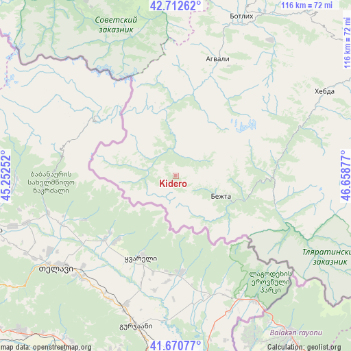
Kidero GPS coordinates[2]
42° 11' 37.824" North, 45° 57' 20.304" East
| Map corner | latitude | longitude |
|---|---|---|
| Upper-left | 42.71262°, | 45.25252° |
| Center: | 42.19384°, | 45.95564° |
| Lower-right: | 41.67077°, | 46.65877° |
| Map W x H: | 115.8×115.8 km | = 72×72mi |
| max Lat: | 73.50819° ⇑99.3% North |
| Kidero: | 42.19384° |
| min Lat: | ⇓0.7% South 41.28413° |
| min Long | Kidero | max Long |
| -179.12198° | 45.95564° | 179.35046° |
| W 52.7%⇐ | ⇒47.3% E |
Elevation
Elevation of Kidero is 2034 m = 6673 ft, and this is 1831.4 m = 6009 ft above average elevation for this country.
| Max E: |
2518 m = 8261 ft | 0.099999999999994% |
| Kidero | 2034 m 6673 ft | |
| Avg. | 202.6 m = 665 ft | |
Min E: |
-28 m = -92 ft | 99.9% |
See also: Russia elevation on elevation.city.
Geographical zone
Kidero is located in North temperate zone (between Tropic of Cancer and the Arctic Circle). Distance of this Northern Tropic circle is 2085.6 km =1295.9 mi to South.| Distance of | km | miles | from Kidero |
|---|---|---|---|
| North Pole | 5315.5 | 3302.9 | to North |
| Arctic Circle | 2709.7 | 1683.7 | to North |
| Tropic Cancer | 2085.6 | 1295.9 | to South |
| Equator | 4691.5 | 2915.2 | to South |


Nearby cities:
15 places around Kidero: (largest is in red/bold)
• Agvali
40.6 km =25.2 mi,  19°
19°
• Aknada
29.2 km =18.1 mi,  37°
37°
• Andi
70.2 km =43.6 mi, 20°
• Ansalta
56.7 km =35.2 mi,  13°
13°
• Bezhta
15.7 km =9.8 mi,  115°
115°
• Borzoy
76.9 km =47.8 mi,  339°
339°
• Gagatli
72.9 km =45.3 mi, 22°
• Itum-Kali
67.8 km =42.1 mi,  332°
332°
• Karata
54.6 km =33.9 mi, 35°
• Khebda
56.4 km =35 mi,  60°
60°
• Khunzakh
72.9 km =45.3 mi, 57°
• Shatoy
78.5 km =48.8 mi, 343°
• Siukh
66.2 km =41.1 mi,  46°
46°
• Tlyarata
34.5 km =21.4 mi,  106°
106°
• Tsurib
72.2 km =44.9 mi,  86°
86°
Sources, notices
• [Note1] Compared only with cities in Russia existing in our database
• [Src1] Map data: © OpenStreetMap contributors (CC-BY-SA)
• [Src2] Other city data from geonames.org with taken over terms of usage.
• [Src3] Geographical zone / Annual Mean Temperature by Robert A. Rohde @ Wikipedia
