Sovetskoye geodata
Sovetskoye (Rostov) is a seat of a second-order administrative division; located in Russia in Europe/Moscow (GMT+3) time zone. In our database, there are 4966 cities with bigger population. Compared to other cities in Russia, 82.6% of cities are located further ↑North; 59.1% of cities are located further →East and 50.2% of cities have higher elevation than Sovetskoye. Note1


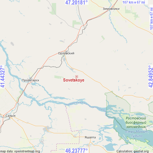
Sovetskoye GPS coordinates[2]
46° 43' 18.984" North, 42° 8' 47.004" East
| Map corner | latitude | longitude |
|---|---|---|
| Upper-left | 47.20181°, | 41.44327° |
| Center: | 46.72194°, | 42.14639° |
| Lower-right: | 46.23777°, | 42.84952° |
| Map W x H: | 107.2×107.2 km | = 66.6×66.6mi |
| max Lat: | 73.50819° ⇑82.6% North |
| Sovetskoye: | 46.72194° |
| min Lat: | ⇓17.4% South 41.28413° |
| min Long | Sovetskoye | max Long |
| -179.12198° | 42.14639° | 179.35046° |
| W 40.9%⇐ | ⇒59.1% E |
Elevation
Elevation of Sovetskoye is 144 m = 472 ft, and this is 58.6 m = 192 ft below average elevation for this country.
| Max E: |
2518 m = 8261 ft | 50.2% |
| Avg. | 202.6 m = 665 ft | |
| Sovetskoye | 144 m = 472 ft | |
Min E: |
-28 m = -92 ft | 49.8% |
See also: Russia elevation on elevation.city.
Geographical zone
Sovetskoye is located in North temperate zone (between Tropic of Cancer and the Arctic Circle). Distance of this North polar circle is 2206.2 km =1370.9 mi to North.| Distance of | km | miles | from Sovetskoye |
|---|---|---|---|
| North Pole | 4812.1 | 2990.1 | to North |
| Arctic Circle | 2206.2 | 1370.9 | to North |
| Tropic Cancer | 2589.1 | 1608.8 | to South |
| Equator | 5195 | 3228 | to South |


Nearby cities:
15 places around Sovetskoye: (largest is in red/bold)
• Bol’shaya Martynovka
71.4 km =44.4 mi,  329°
329°
• Gigant
65.9 km =40.9 mi,  248°
248°
• Gorodoviki
66.7 km =41.4 mi,  191°
191°
• Gorodovikovsk
72.4 km =45 mi, 193°
• Gundorovskiy
20.1 km =12.5 mi,  288°
288°
• Krasnaya Polyana
83.8 km =52.1 mi,  216°
216°
• Krasnoarmeyskiy
32.5 km =20.2 mi,  8°
8°
• Novyy Yegorlyk
42.2 km =26.2 mi,  209°
209°
• Orlovskiy
17.9 km =11.1 mi,  338°
338°
• Proletarsk
32 km =19.9 mi,  266°
266°
• Sal’sk
53.8 km =33.4 mi,  239°
239°
• Sandata
58.3 km =36.2 mi, 210°
• Volochayevskiy
43.4 km =27 mi,  117°
117°
• Yashalta
43.7 km =27.2 mi,  166°
166°
• Zimovniki
53.4 km =33.2 mi,  27°
27°
Sources, notices
• [Note1] Compared only with cities in Russia existing in our database
• [Src1] Map data: © OpenStreetMap contributors (CC-BY-SA)
• [Src2] Other city data from geonames.org with taken over terms of usage.
• [Src3] Geographical zone / Annual Mean Temperature by Robert A. Rohde @ Wikipedia
