Sal’sk geodata
Sal’sk (Rostov) is a seat of a second-order administrative division; located in Russia in Europe/Moscow (GMT+3) time zone. With population of 61,000 people, there are 345 cities with bigger population in this country. Compared to other cities in Russia, 83.1% of cities are located further ↑North; 61.2% of cities are located further →East and 87.5% of cities have higher elevation than Sal’sk. Note1


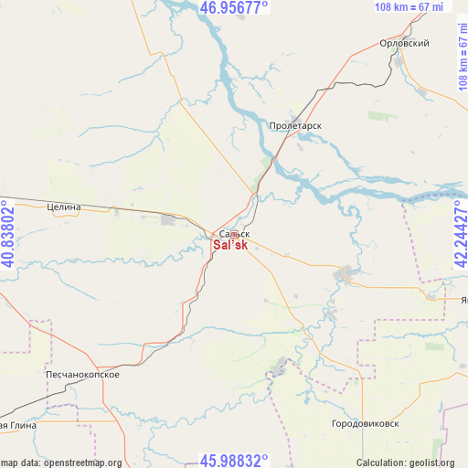
Sal’sk GPS coordinates[2]
46° 28' 28.92" North, 41° 32' 28.104" East
| Map corner | latitude | longitude |
|---|---|---|
| Upper-left | 46.95677°, | 40.83802° |
| Center: | 46.4747°, | 41.54114° |
| Lower-right: | 45.98832°, | 42.24427° |
| Map W x H: | 107.7×107.7 km | = 66.9×66.9mi |
| max Lat: | 73.50819° ⇑83.1% North |
| Sal’sk: | 46.4747° |
| min Lat: | ⇓16.9% South 41.28413° |
| min Long | Sal’sk | max Long |
| -179.12198° | 41.54114° | 179.35046° |
| W 38.8%⇐ | ⇒61.2% E |
Elevation
Elevation of Sal’sk is 38 m = 125 ft, and this is 164.6 m = 540 ft below average elevation for this country.
| Max E: |
2518 m = 8261 ft | 87.5% |
| Avg. | 202.6 m = 665 ft | |
| Sal’sk | 38 m = 125 ft | |
Min E: |
-28 m = -92 ft | 12.5% |
See also: Sal’sk elevation on elevation.city.
Geographical zone
Sal’sk is located in North temperate zone (between Tropic of Cancer and the Arctic Circle). Distance of this North polar circle is 2233.7 km =1388 mi to North.| Distance of | km | miles | from Sal’sk |
|---|---|---|---|
| North Pole | 4839.6 | 3007.2 | to North |
| Arctic Circle | 2233.7 | 1388 | to North |
| Tropic Cancer | 2561.6 | 1591.7 | to South |
| Equator | 5167.5 | 3210.9 | to South |


Nearby cities:
15 places around Sal’sk: (largest is in red/bold)
• Belaya Glina
68.1 km =42.3 mi,  229°
229°
• Gigant
15.7 km =9.8 mi,  283°
283°
• Gorodoviki
49.9 km =31 mi,  139°
139°
• Gorodovikovsk
52.5 km =32.6 mi, 144°
• Gundorovskiy
43.5 km =27 mi,  38°
38°
• Krasnaya Polyana
40.3 km =25 mi,  184°
184°
• Letnik
55.7 km =34.6 mi,  202°
202°
• Novyy Yegorlyk
26.9 km =16.7 mi,  109°
109°
• Orlovskiy
59.2 km =36.8 mi, 41°
• Peschanokopskoye
47 km =29.2 mi, 228°
• Proletarsk
29.1 km =18.1 mi,  29°
29°
• Sandata
28.1 km =17.5 mi, 143°
• Sovetskoye
53.8 km =33.4 mi,  59°
59°
• Tselina
39.5 km =24.5 mi, 279°
• Yashalta
58.3 km =36.2 mi,  104°
104°
Sources, notices
• [Note1] Compared only with cities in Russia existing in our database
• [Src1] Map data: © OpenStreetMap contributors (CC-BY-SA)
• [Src2] Other city data from geonames.org with taken over terms of usage.
• [Src3] Geographical zone / Annual Mean Temperature by Robert A. Rohde @ Wikipedia
