Falënki geodata
Falënki (Kirov) is a populated place; located in Russia in Europe/Kirov (GMT+3) time zone. With population of 5,303 people, there are 2510 cities with bigger population in this country. Compared to other cities in Russia, 84.1% of cities are located further ↓South; 63.6% of cities are located further ←West and 55.3% of cities have lower elevation than Falënki. Note1


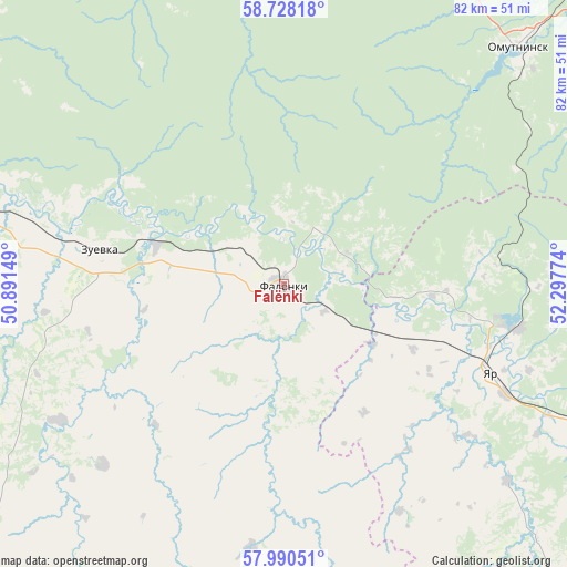
Falënki GPS coordinates[2]
58° 21' 40.572" North, 51° 35' 40.596" East
| Map corner | latitude | longitude |
|---|---|---|
| Upper-left | 58.72818°, | 50.89149° |
| Center: | 58.36127°, | 51.59461° |
| Lower-right: | 57.99051°, | 52.29774° |
| Map W x H: | 82×82 km | = 51×51mi |
| max Lat: | 73.50819° ⇑15.9% North |
| Falënki: | 58.36127° |
| min Lat: | ⇓84.1% South 41.28413° |
| min Long | Falënki | max Long |
| -179.12198° | 51.59461° | 179.35046° |
| W 63.6%⇐ | ⇒36.4% E |
Elevation
Elevation of Falënki is 157 m = 515 ft, and this is 45.6 m = 150 ft below average elevation for this country.
| Max E: |
2518 m = 8261 ft | 44.7% |
| Avg. | 202.6 m = 665 ft | |
| Falënki | 157 m = 515 ft | |
Min E: |
-28 m = -92 ft | 55.3% |
See also: Russia elevation on elevation.city.
Geographical zone
Falënki is located in North temperate zone (between Tropic of Cancer and the Arctic Circle). Distance of this North polar circle is 912 km =566.7 mi to North.| Distance of | km | miles | from Falënki |
|---|---|---|---|
| North Pole | 3517.9 | 2185.9 | to North |
| Arctic Circle | 912 | 566.7 | to North |
| Tropic Cancer | 3883.2 | 2412.9 | to South |
| Equator | 6489.2 | 4032.2 | to South |


Nearby cities:
15 places around Falënki: (largest is in red/bold)
• Belaya Kholunitsa
68.4 km =42.5 mi,  321°
321°
• Belorechensk
61.1 km =38 mi,  41°
41°
• Bogorodskoye
77.3 km =48 mi,  220°
220°
• Chërnaya Kholunitsa
54.9 km =34.1 mi,  7°
7°
• Glazov
66.9 km =41.6 mi,  111°
111°
• Karintorf
84.6 km =52.6 mi,  284°
284°
• Kosino
19.3 km =12 mi,  287°
287°
• Lesnyye Polyany
85.8 km =53.3 mi,  33°
33°
• Omutninsk
48.9 km =30.4 mi,  45°
45°
• Pudem
34 km =21.1 mi,  100°
100°
• Uni
68.1 km =42.3 mi,  185°
185°
• Vostochnyy
60.6 km =37.7 mi, 38°
• Yar
32.5 km =20.2 mi, 113°
• Yukamenskoye
65 km =40.4 mi,  144°
144°
• Zuyevka
27.3 km =17 mi, 280°
Sources, notices
• [Note1] Compared only with cities in Russia existing in our database
• [Src1] Map data: © OpenStreetMap contributors (CC-BY-SA)
• [Src2] Other city data from geonames.org with taken over terms of usage.
• [Src3] Geographical zone / Annual Mean Temperature by Robert A. Rohde @ Wikipedia
