Yukamenskoye geodata
Yukamenskoye (Udmurtiya Republic) is a populated place; located in Russia in Europe/Samara (GMT+4) time zone. With population of 4,278 people, there are 2961 cities with bigger population in this country. Compared to other cities in Russia, 82.1% of cities are located further ↓South; 64.1% of cities are located further ←West and 63.8% of cities have lower elevation than Yukamenskoye. Note1


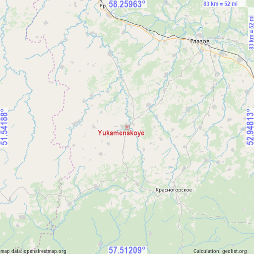
Yukamenskoye GPS coordinates[2]
57° 53' 16.08" North, 52° 14' 42" East
| Map corner | latitude | longitude |
|---|---|---|
| Upper-left | 58.25963°, | 51.54188° |
| Center: | 57.8878°, | 52.245° |
| Lower-right: | 57.51209°, | 52.94813° |
| Map W x H: | 83.1×83.1 km | = 51.6×51.6mi |
| max Lat: | 73.50819° ⇑17.9% North |
| Yukamenskoye: | 57.8878° |
| min Lat: | ⇓82.1% South 41.28413° |
| min Long | Yukamenskoye | max Long |
| -179.12198° | 52.245° | 179.35046° |
| W 64.1%⇐ | ⇒35.9% E |
Elevation
Elevation of Yukamenskoye is 179 m = 587 ft, and this is 23.6 m = 77 ft below average elevation for this country.
| Max E: |
2518 m = 8261 ft | 36.2% |
| Avg. | 202.6 m = 665 ft | |
| Yukamenskoye | 179 m = 587 ft | |
Min E: |
-28 m = -92 ft | 63.8% |
See also: Russia elevation on elevation.city.
Geographical zone
Yukamenskoye is located in North temperate zone (between Tropic of Cancer and the Arctic Circle). Distance of this North polar circle is 964.7 km =599.4 mi to North.| Distance of | km | miles | from Yukamenskoye |
|---|---|---|---|
| North Pole | 3570.5 | 2218.6 | to North |
| Arctic Circle | 964.7 | 599.4 | to North |
| Tropic Cancer | 3830.6 | 2380.2 | to South |
| Equator | 6436.5 | 3999.5 | to South |


Nearby cities:
15 places around Yukamenskoye: (largest is in red/bold)
• Balezino
46.5 km =28.9 mi,  77°
77°
• Fakel
54.4 km =33.8 mi,  121°
121°
• Falënki
65 km =40.4 mi,  324°
324°
• Glazov
37.1 km =23.1 mi,  41°
41°
• Igra
60.7 km =37.7 mi,  127°
127°
• Kez
86.8 km =53.9 mi,  89°
89°
• Kosino
81.4 km =50.6 mi, 315°
• Krasnogorskoye
25.4 km =15.8 mi,  143°
143°
• Omutninsk
87 km =54.1 mi,  358°
358°
• Pudem
46.6 km =29 mi,  354°
354°
• Selty
64.2 km =39.9 mi,  185°
185°
• Uni
47.2 km =29.3 mi,  251°
251°
• Yar
40.6 km =25.2 mi, 348°
• Yunda
38.5 km =23.9 mi, 90°
• Zuyevka
87 km =54.1 mi,  311°
311°
Sources, notices
• [Note1] Compared only with cities in Russia existing in our database
• [Src1] Map data: © OpenStreetMap contributors (CC-BY-SA)
• [Src2] Other city data from geonames.org with taken over terms of usage.
• [Src3] Geographical zone / Annual Mean Temperature by Robert A. Rohde @ Wikipedia
