Dolgorukovo geodata
Dolgorukovo (Lipetsk Oblast) is a populated place; located in Russia in Europe/Moscow (GMT+3) time zone. With population of 5,599 people, there are 2402 cities with bigger population in this country. Compared to other cities in Russia, 67.2% of cities are located further ↑North; 75.2% of cities are located further →East and 69% of cities have lower elevation than Dolgorukovo. Note1


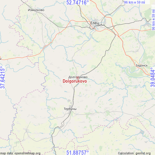
Dolgorukovo GPS coordinates[2]
52° 19' 10.02" North, 38° 20' 42.972" East
| Map corner | latitude | longitude |
|---|---|---|
| Upper-left | 52.74716°, | 37.64215° |
| Center: | 52.31945°, | 38.34527° |
| Lower-right: | 51.88757°, | 39.0484° |
| Map W x H: | 95.6×95.6 km | = 59.4×59.4mi |
| max Lat: | 73.50819° ⇑67.2% North |
| Dolgorukovo: | 52.31945° |
| min Lat: | ⇓32.8% South 41.28413° |
| min Long | Dolgorukovo | max Long |
| -179.12198° | 38.34527° | 179.35046° |
| W 24.8%⇐ | ⇒75.2% E |
Elevation
Elevation of Dolgorukovo is 194 m = 636 ft, and this is 8.6 m = 28 ft below average elevation for this country.
| Max E: |
2518 m = 8261 ft | 31% |
| Avg. | 202.6 m = 665 ft | |
| Dolgorukovo | 194 m = 636 ft | |
Min E: |
-28 m = -92 ft | 69% |
See also: Russia elevation on elevation.city.
Geographical zone
Dolgorukovo is located in North temperate zone (between Tropic of Cancer and the Arctic Circle). Distance of this North polar circle is 1583.8 km =984.1 mi to North.| Distance of | km | miles | from Dolgorukovo |
|---|---|---|---|
| North Pole | 4189.7 | 2603.4 | to North |
| Arctic Circle | 1583.8 | 984.1 | to North |
| Tropic Cancer | 3211.5 | 1995.5 | to South |
| Equator | 5817.4 | 3614.8 | to South |


Nearby cities:
15 places around Dolgorukovo: (largest is in red/bold)
• Donskoye
53.9 km =33.5 mi,  52°
52°
• Izmalkovo
48.5 km =30.1 mi,  327°
327°
• Kastornoye
56 km =34.8 mi,  195°
195°
• Kazaki
34.4 km =21.4 mi,  350°
350°
• Khlevnoye
52.7 km =32.7 mi,  105°
105°
• Krasnaya Zarya
68.3 km =42.4 mi,  318°
318°
• Krasnoye
67.7 km =42.1 mi,  26°
26°
• Kshenskiy
68.5 km =42.6 mi,  219°
219°
• Livny
51.5 km =32 mi,  283°
283°
• Stanovoye
49.4 km =30.7 mi,  1°
1°
• Terbuny
19.4 km =12.1 mi,  192°
192°
• Volovo
45.2 km =28.1 mi, 223°
• Yelets
35.4 km =22 mi,  17°
17°
• Zadonsk
40.2 km =25 mi,  78°
78°
• Zemlyansk
53.2 km =33.1 mi,  150°
150°
Sources, notices
• [Note1] Compared only with cities in Russia existing in our database
• [Src1] Map data: © OpenStreetMap contributors (CC-BY-SA)
• [Src2] Other city data from geonames.org with taken over terms of usage.
• [Src3] Geographical zone / Annual Mean Temperature by Robert A. Rohde @ Wikipedia
