Terbuny geodata
Terbuny (Lipetsk Oblast) is a populated place; located in Russia in Europe/Moscow (GMT+3) time zone. With population of 6,936 people, there are 2017 cities with bigger population in this country. Compared to other cities in Russia, 68.3% of cities are located further ↑North; 75.4% of cities are located further →East and 76.7% of cities have lower elevation than Terbuny. Note1


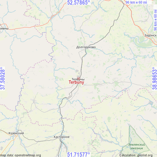
Terbuny GPS coordinates[2]
52° 8' 57.48" North, 38° 17' 0.24" East
| Map corner | latitude | longitude |
|---|---|---|
| Upper-left | 52.57865°, | 37.58028° |
| Center: | 52.1493°, | 38.2834° |
| Lower-right: | 51.71577°, | 38.98653° |
| Map W x H: | 95.9×95.9 km | = 59.6×59.6mi |
| max Lat: | 73.50819° ⇑68.3% North |
| Terbuny: | 52.1493° |
| min Lat: | ⇓31.7% South 41.28413° |
| min Long | Terbuny | max Long |
| -179.12198° | 38.2834° | 179.35046° |
| W 24.6%⇐ | ⇒75.4% E |
Elevation
Elevation of Terbuny is 225 m = 738 ft, and this is 22.4 m = 73 ft above average elevation for this country.
| Max E: |
2518 m = 8261 ft | 23.3% |
| Terbuny | 225 m 738 ft | |
| Avg. | 202.6 m = 665 ft | |
Min E: |
-28 m = -92 ft | 76.7% |
See also: Russia elevation on elevation.city.
Geographical zone
Terbuny is located in North temperate zone (between Tropic of Cancer and the Arctic Circle). Distance of this North polar circle is 1602.7 km =995.9 mi to North.| Distance of | km | miles | from Terbuny |
|---|---|---|---|
| North Pole | 4208.6 | 2615.1 | to North |
| Arctic Circle | 1602.7 | 995.9 | to North |
| Tropic Cancer | 3192.5 | 1983.7 | to South |
| Equator | 5798.5 | 3603 | to South |


Nearby cities:
15 places around Terbuny: (largest is in red/bold)
• Dolgorukovo
19.4 km =12.1 mi,  12°
12°
• Izmalkovo
63.8 km =39.6 mi,  340°
340°
• Kastornoye
36.7 km =22.8 mi,  196°
196°
• Kazaki
52.9 km =32.9 mi,  358°
358°
• Khlevnoye
55.5 km =34.5 mi,  84°
84°
• Kshenskiy
51.9 km =32.2 mi,  228°
228°
• Livny
55.3 km =34.4 mi,  303°
303°
• Nizhnedevitsk
67.8 km =42.1 mi,  175°
175°
• Novozhivotinnoye
67.2 km =41.8 mi,  115°
115°
• Olym
52.7 km =32.7 mi,  188°
188°
• Volovo
30.4 km =18.9 mi,  243°
243°
• Vyshneye Dolgoye
60.7 km =37.7 mi,  260°
260°
• Yelets
54.8 km =34.1 mi,  15°
15°
• Zadonsk
51.3 km =31.9 mi,  58°
58°
• Zemlyansk
41.1 km =25.5 mi,  131°
131°
Sources, notices
• [Note1] Compared only with cities in Russia existing in our database
• [Src1] Map data: © OpenStreetMap contributors (CC-BY-SA)
• [Src2] Other city data from geonames.org with taken over terms of usage.
• [Src3] Geographical zone / Annual Mean Temperature by Robert A. Rohde @ Wikipedia
