Kastornoye geodata
Kastornoye (Kursk) is a populated place; located in Russia in Europe/Moscow (GMT+3) time zone. With population of 4,390 people, there are 2915 cities with bigger population in this country. Compared to other cities in Russia, 70.3% of cities are located further ↑North; 76.4% of cities are located further →East and 58.8% of cities have lower elevation than Kastornoye. Note1


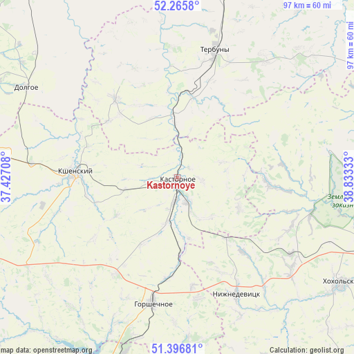
Kastornoye GPS coordinates[2]
51° 50' 0.24" North, 38° 7' 48.72" East
| Map corner | latitude | longitude |
|---|---|---|
| Upper-left | 52.2658°, | 37.42708° |
| Center: | 51.8334°, | 38.1302° |
| Lower-right: | 51.39681°, | 38.83333° |
| Map W x H: | 96.6×96.6 km | = 60×60mi |
| max Lat: | 73.50819° ⇑70.3% North |
| Kastornoye: | 51.8334° |
| min Lat: | ⇓29.7% South 41.28413° |
| min Long | Kastornoye | max Long |
| -179.12198° | 38.1302° | 179.35046° |
| W 23.6%⇐ | ⇒76.4% E |
Elevation
Elevation of Kastornoye is 165 m = 541 ft, and this is 37.6 m = 123 ft below average elevation for this country.
| Max E: |
2518 m = 8261 ft | 41.2% |
| Avg. | 202.6 m = 665 ft | |
| Kastornoye | 165 m = 541 ft | |
Min E: |
-28 m = -92 ft | 58.8% |
See also: Russia elevation on elevation.city.
Geographical zone
Kastornoye is located in North temperate zone (between Tropic of Cancer and the Arctic Circle). Distance of this North polar circle is 1637.8 km =1017.7 mi to North.| Distance of | km | miles | from Kastornoye |
|---|---|---|---|
| North Pole | 4243.7 | 2636.9 | to North |
| Arctic Circle | 1637.8 | 1017.7 | to North |
| Tropic Cancer | 3157.4 | 1961.9 | to South |
| Equator | 5763.3 | 3581.1 | to South |


Nearby cities:
15 places around Kastornoye: (largest is in red/bold)
• Cheremisinovo
59.7 km =37.1 mi,  275°
275°
• Devitsa
60.3 km =37.5 mi,  111°
111°
• Dolgorukovo
56 km =34.8 mi,  15°
15°
• Gorshechnoye
35 km =21.7 mi,  190°
190°
• Kshenskiy
28.6 km =17.8 mi,  271°
271°
• Latnaya
56.5 km =35.1 mi, 110°
• Nizhnedevitsk
36.2 km =22.5 mi,  153°
153°
• Olym
17.4 km =10.8 mi,  169°
169°
• Semiluki
63.9 km =39.7 mi,  104°
104°
• Staryy Oskol
62.9 km =39.1 mi,  198°
198°
• Strelitsa
59.3 km =36.8 mi, 114°
• Terbuny
36.7 km =22.8 mi, 16°
• Volovo
27.3 km =17 mi,  321°
321°
• Vyshneye Dolgoye
55.9 km =34.7 mi,  297°
297°
• Zemlyansk
42.2 km =26.2 mi,  79°
79°
Sources, notices
• [Note1] Compared only with cities in Russia existing in our database
• [Src1] Map data: © OpenStreetMap contributors (CC-BY-SA)
• [Src2] Other city data from geonames.org with taken over terms of usage.
• [Src3] Geographical zone / Annual Mean Temperature by Robert A. Rohde @ Wikipedia
