Danilov geodata
Danilov (Jaroslavl) is a populated place; located in Russia in Europe/Moscow (GMT+3) time zone. With population of 16,808 people, there are 1006 cities with bigger population in this country. Compared to other cities in Russia, 83.4% of cities are located further ↓South; 66.7% of cities are located further →East and 62.4% of cities have lower elevation than Danilov. Note1


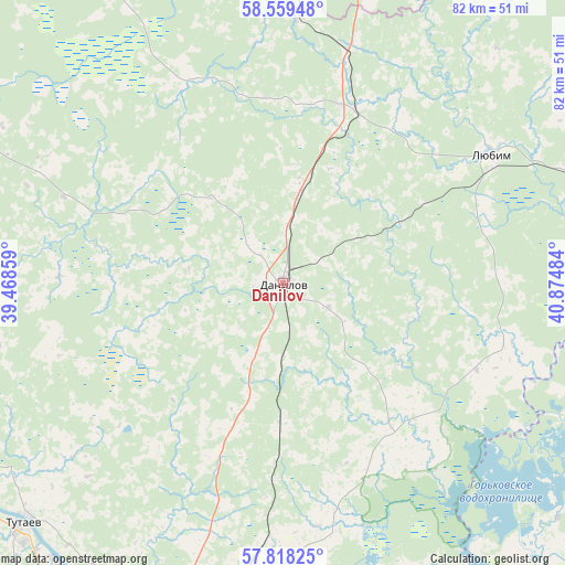
Danilov GPS coordinates[2]
58° 11' 26.88" North, 40° 10' 18.156" East
| Map corner | latitude | longitude |
|---|---|---|
| Upper-left | 58.55948°, | 39.46859° |
| Center: | 58.1908°, | 40.17171° |
| Lower-right: | 57.81825°, | 40.87484° |
| Map W x H: | 82.4×82.4 km | = 51.2×51.2mi |
| max Lat: | 73.50819° ⇑16.6% North |
| Danilov: | 58.1908° |
| min Lat: | ⇓83.4% South 41.28413° |
| min Long | Danilov | max Long |
| -179.12198° | 40.17171° | 179.35046° |
| W 33.3%⇐ | ⇒66.7% E |
Elevation
Elevation of Danilov is 175 m = 574 ft, and this is 27.6 m = 91 ft below average elevation for this country.
| Max E: |
2518 m = 8261 ft | 37.6% |
| Avg. | 202.6 m = 665 ft | |
| Danilov | 175 m = 574 ft | |
Min E: |
-28 m = -92 ft | 62.4% |
See also: Russia elevation on elevation.city.
Geographical zone
Danilov is located in North temperate zone (between Tropic of Cancer and the Arctic Circle). Distance of this North polar circle is 931 km =578.5 mi to North.| Distance of | km | miles | from Danilov |
|---|---|---|---|
| North Pole | 3536.9 | 2197.7 | to North |
| Arctic Circle | 931 | 578.5 | to North |
| Tropic Cancer | 3864.3 | 2401.2 | to South |
| Equator | 6470.2 | 4020.4 | to South |


Nearby cities:
15 places around Danilov: (largest is in red/bold)
• Konstantinovskiy
52.8 km =32.8 mi,  220°
220°
• Kostroma
64.9 km =40.3 mi,  136°
136°
• Krasnyy Profintern
52 km =32.3 mi,  162°
162°
• Kukoboy
58.7 km =36.5 mi,  345°
345°
• Levashevo
64.2 km =39.9 mi, 161°
• Lyubim
35.5 km =22.1 mi,  57°
57°
• Nagornyy
72.7 km =45.2 mi,  195°
195°
• Nekrasovskoye
58.3 km =36.2 mi,  168°
168°
• Oktyabr’skiy
69.7 km =43.3 mi, 135°
• Pesochnoye
61.9 km =38.5 mi,  250°
250°
• Poshekhon’ye
69.5 km =43.2 mi,  299°
299°
• Prechistoye
27.4 km =17 mi,  21°
21°
• Tunoshna
71.8 km =44.6 mi,  182°
182°
• Tutayev
50.3 km =31.3 mi,  227°
227°
• Yaroslavl
64.8 km =40.3 mi, 195°
Sources, notices
• [Note1] Compared only with cities in Russia existing in our database
• [Src1] Map data: © OpenStreetMap contributors (CC-BY-SA)
• [Src2] Other city data from geonames.org with taken over terms of usage.
• [Src3] Geographical zone / Annual Mean Temperature by Robert A. Rohde @ Wikipedia
