Maykop geodata
Maykop (Adygeya Republic) is a seat of a first-order administrative division; located in Russia in Europe/Moscow (GMT+3) time zone. With population of 144,055 people, there are 134 cities with bigger population in this country. Compared to other cities in Russia, 89.2% of cities are located further ↑North; 67.1% of cities are located further →East and 77.1% of cities have lower elevation than Maykop. Note1


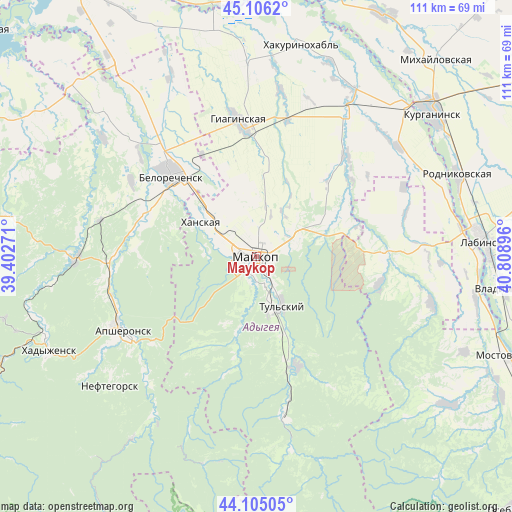
Maykop GPS coordinates[2]
44° 36' 28.008" North, 40° 6' 20.988" East
| Map corner | latitude | longitude |
|---|---|---|
| Upper-left | 45.1062°, | 39.40271° |
| Center: | 44.60778°, | 40.10583° |
| Lower-right: | 44.10505°, | 40.80896° |
| Map W x H: | 111.3×111.3 km | = 69.2×69.2mi |
| max Lat: | 73.50819° ⇑89.2% North |
| Maykop: | 44.60778° |
| min Lat: | ⇓10.8% South 41.28413° |
| min Long | Maykop | max Long |
| -179.12198° | 40.10583° | 179.35046° |
| W 32.9%⇐ | ⇒67.1% E |
Elevation
Elevation of Maykop is 227 m = 745 ft, and this is 24.4 m = 80 ft above average elevation for this country.
| Max E: |
2518 m = 8261 ft | 22.9% |
| Maykop | 227 m 745 ft | |
| Avg. | 202.6 m = 665 ft | |
Min E: |
-28 m = -92 ft | 77.1% |
See also: Maykop elevation on elevation.city.
Geographical zone
Maykop is located in North temperate zone (between Tropic of Cancer and the Arctic Circle). Distance of this Northern Tropic circle is 2354 km =1462.7 mi to South.| Distance of | km | miles | from Maykop |
|---|---|---|---|
| North Pole | 5047.1 | 3136.1 | to North |
| Arctic Circle | 2441.3 | 1517 | to North |
| Tropic Cancer | 2354 | 1462.7 | to South |
| Equator | 4959.9 | 3081.9 | to South |


Nearby cities:
15 places around Maykop: (largest is in red/bold)
• Abadzekhskaya
25.5 km =15.8 mi,  158°
158°
• Apsheronsk
33.5 km =20.8 mi,  241°
241°
• Belorechensk
25.5 km =15.8 mi,  315°
315°
• Blechepsin
39.1 km =24.3 mi,  52°
52°
• Dondukovskaya
36.6 km =22.7 mi,  33°
33°
• Giaginskaya
28.4 km =17.6 mi,  354°
354°
• Kamennomostskiy
36 km =22.4 mi,  169°
169°
• Khanskaya
13.8 km =8.6 mi,  304°
304°
• Kuzhorskaya
17.8 km =11.1 mi,  65°
65°
• Natyrbovo
43.3 km =26.9 mi, 71°
• Neftegorsk
41.5 km =25.8 mi,  229°
229°
• Pshekhskaya
26.3 km =16.3 mi,  291°
291°
• Tul’skiy
12 km =7.5 mi,  151°
151°
• Yaroslavskaya
28.4 km =17.6 mi,  89°
89°
• Yuzhnyy
21.9 km =13.6 mi,  305°
305°
Sources, notices
• [Note1] Compared only with cities in Russia existing in our database
• [Src1] Map data: © OpenStreetMap contributors (CC-BY-SA)
• [Src2] Other city data from geonames.org with taken over terms of usage.
• [Src3] Geographical zone / Annual Mean Temperature by Robert A. Rohde @ Wikipedia
