Tul’skiy geodata
Tul’skiy (Adygeya Republic) is a seat of a second-order administrative division; located in Russia in Europe/Moscow (GMT+3) time zone. In our database, there are 4966 cities with bigger population. Compared to other cities in Russia, 89.4% of cities are located further ↑North; 66.7% of cities are located further →East and 82.7% of cities have lower elevation than Tul’skiy. Note1


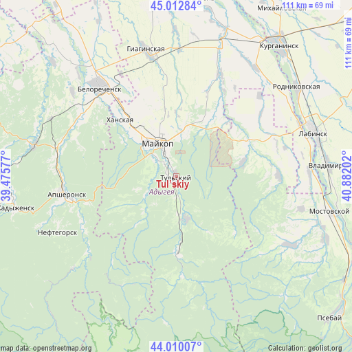
Tul’skiy GPS coordinates[2]
44° 30' 48.996" North, 40° 10' 44.004" East
| Map corner | latitude | longitude |
|---|---|---|
| Upper-left | 45.01284°, | 39.47577° |
| Center: | 44.51361°, | 40.17889° |
| Lower-right: | 44.01007°, | 40.88202° |
| Map W x H: | 111.5×111.5 km | = 69.3×69.3mi |
| max Lat: | 73.50819° ⇑89.4% North |
| Tul’skiy: | 44.51361° |
| min Lat: | ⇓10.6% South 41.28413° |
| min Long | Tul’skiy | max Long |
| -179.12198° | 40.17889° | 179.35046° |
| W 33.3%⇐ | ⇒66.7% E |
Elevation
Elevation of Tul’skiy is 281 m = 922 ft, and this is 78.4 m = 257 ft above average elevation for this country.
| Max E: |
2518 m = 8261 ft | 17.3% |
| Tul’skiy | 281 m 922 ft | |
| Avg. | 202.6 m = 665 ft | |
Min E: |
-28 m = -92 ft | 82.7% |
See also: Russia elevation on elevation.city.
Geographical zone
Tul’skiy is located in North temperate zone (between Tropic of Cancer and the Arctic Circle). Distance of this Northern Tropic circle is 2343.5 km =1456.2 mi to South.| Distance of | km | miles | from Tul’skiy |
|---|---|---|---|
| North Pole | 5057.6 | 3142.6 | to North |
| Arctic Circle | 2451.7 | 1523.4 | to North |
| Tropic Cancer | 2343.5 | 1456.2 | to South |
| Equator | 4949.4 | 3075.4 | to South |


Nearby cities:
15 places around Tul’skiy: (largest is in red/bold)
• Abadzekhskaya
13.7 km =8.5 mi,  165°
165°
• Apsheronsk
35.7 km =22.2 mi,  261°
261°
• Belorechensk
37.2 km =23.1 mi,  320°
320°
• Giaginskaya
39.7 km =24.7 mi,  347°
347°
• Gubskaya
42.4 km =26.3 mi,  121°
121°
• Kamennomostskiy
25 km =15.5 mi,  178°
178°
• Khanskaya
25 km =15.5 mi, 316°
• Khodz’
42.4 km =26.3 mi,  90°
90°
• Kuzhorskaya
20.8 km =12.9 mi,  30°
30°
• Maykop
12 km =7.5 mi,  331°
331°
• Mezmay
39 km =24.2 mi,  206°
206°
• Neftegorsk
40.9 km =25.4 mi,  246°
246°
• Pshekhskaya
36.4 km =22.6 mi,  303°
303°
• Yaroslavskaya
25 km =15.5 mi,  64°
64°
• Yuzhnyy
33.1 km =20.6 mi,  314°
314°
Sources, notices
• [Note1] Compared only with cities in Russia existing in our database
• [Src1] Map data: © OpenStreetMap contributors (CC-BY-SA)
• [Src2] Other city data from geonames.org with taken over terms of usage.
• [Src3] Geographical zone / Annual Mean Temperature by Robert A. Rohde @ Wikipedia
