Malaya Purga geodata
Malaya Purga (Udmurtiya Republic) is a populated place; located in Russia in Europe/Samara (GMT+4) time zone. With population of 6,803 people, there are 2046 cities with bigger population in this country. Compared to other cities in Russia, 73.3% of cities are located further ↓South; 64.8% of cities are located further ←West and 65% of cities have higher elevation than Malaya Purga. Note1


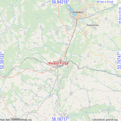
Malaya Purga GPS coordinates[2]
56° 33' 23.976" North, 53° 0' 15.624" East
| Map corner | latitude | longitude |
|---|---|---|
| Upper-left | 56.94218°, | 52.30122° |
| Center: | 56.55666°, | 53.00434° |
| Lower-right: | 56.16717°, | 53.70747° |
| Map W x H: | 86.2×86.2 km | = 53.6×53.6mi |
| max Lat: | 73.50819° ⇑26.7% North |
| Malaya Purga: | 56.55666° |
| min Lat: | ⇓73.3% South 41.28413° |
| min Long | Malaya Purga | max Long |
| -179.12198° | 53.00434° | 179.35046° |
| W 64.8%⇐ | ⇒35.2% E |
Elevation
Elevation of Malaya Purga is 114 m = 374 ft, and this is 88.6 m = 291 ft below average elevation for this country.
| Max E: |
2518 m = 8261 ft | 65% |
| Avg. | 202.6 m = 665 ft | |
| Malaya Purga | 114 m = 374 ft | |
Min E: |
-28 m = -92 ft | 35% |
See also: Russia elevation on elevation.city.
Geographical zone
Malaya Purga is located in North temperate zone (between Tropic of Cancer and the Arctic Circle). Distance of this North polar circle is 1112.7 km =691.4 mi to North.| Distance of | km | miles | from Malaya Purga |
|---|---|---|---|
| North Pole | 3718.6 | 2310.6 | to North |
| Arctic Circle | 1112.7 | 691.4 | to North |
| Tropic Cancer | 3682.6 | 2288.3 | to South |
| Equator | 6288.5 | 3907.5 | to South |


Nearby cities:
15 places around Malaya Purga: (largest is in red/bold)
• Agryz
4.1 km =2.5 mi,  188°
188°
• Alnashi
52.3 km =32.5 mi,  218°
218°
• Chaykovskiy
71.8 km =44.6 mi,  70°
70°
• Izhevsk
34.8 km =21.6 mi,  20°
20°
• Kama
72.6 km =45.1 mi,  112°
112°
• Karakulino
74.5 km =46.3 mi,  144°
144°
• Khokhryaki
44.4 km =27.6 mi,  25°
25°
• Kiyasovo
24.2 km =15 mi,  162°
162°
• Mozhga
49.3 km =30.6 mi,  255°
255°
• Pirogovo
26.3 km =16.3 mi, 19°
• Pychas
35.1 km =21.8 mi, 260°
• Sarapul
49.5 km =30.8 mi,  100°
100°
• Sigayevo
49.7 km =30.9 mi, 107°
• Uva
69.4 km =43.1 mi,  314°
314°
• Vavozh
69.9 km =43.4 mi,  290°
290°
Sources, notices
• [Note1] Compared only with cities in Russia existing in our database
• [Src1] Map data: © OpenStreetMap contributors (CC-BY-SA)
• [Src2] Other city data from geonames.org with taken over terms of usage.
• [Src3] Geographical zone / Annual Mean Temperature by Robert A. Rohde @ Wikipedia
