Kiyasovo geodata
Kiyasovo (Udmurtiya Republic) is a populated place; located in Russia in Europe/Samara (GMT+4) time zone. With population of 3,265 people, there are 3554 cities with bigger population in this country. Compared to other cities in Russia, 71.1% of cities are located further ↓South; 64.9% of cities are located further ←West and 59.9% of cities have lower elevation than Kiyasovo. Note1


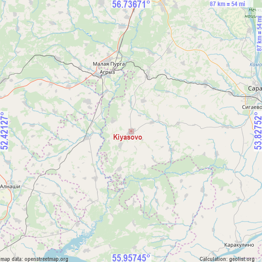
Kiyasovo GPS coordinates[2]
56° 20' 56.652" North, 53° 7' 27.804" East
| Map corner | latitude | longitude |
|---|---|---|
| Upper-left | 56.73671°, | 52.42127° |
| Center: | 56.34907°, | 53.12439° |
| Lower-right: | 55.95745°, | 53.82752° |
| Map W x H: | 86.6×86.6 km | = 53.8×53.8mi |
| max Lat: | 73.50819° ⇑28.9% North |
| Kiyasovo: | 56.34907° |
| min Lat: | ⇓71.1% South 41.28413° |
| min Long | Kiyasovo | max Long |
| -179.12198° | 53.12439° | 179.35046° |
| W 64.9%⇐ | ⇒35.1% E |
Elevation
Elevation of Kiyasovo is 168 m = 551 ft, and this is 34.6 m = 114 ft below average elevation for this country.
| Max E: |
2518 m = 8261 ft | 40.1% |
| Avg. | 202.6 m = 665 ft | |
| Kiyasovo | 168 m = 551 ft | |
Min E: |
-28 m = -92 ft | 59.9% |
See also: Russia elevation on elevation.city.
Geographical zone
Kiyasovo is located in North temperate zone (between Tropic of Cancer and the Arctic Circle). Distance of this North polar circle is 1135.7 km =705.7 mi to North.| Distance of | km | miles | from Kiyasovo |
|---|---|---|---|
| North Pole | 3741.6 | 2324.9 | to North |
| Arctic Circle | 1135.7 | 705.7 | to North |
| Tropic Cancer | 3659.5 | 2273.9 | to South |
| Equator | 6265.4 | 3893.1 | to South |


Nearby cities:
15 places around Kiyasovo: (largest is in red/bold)
• Agryz
20.7 km =12.9 mi,  337°
337°
• Alnashi
43.7 km =27.2 mi,  245°
245°
• Izhevsk
55.9 km =34.7 mi,  5°
5°
• Kama
60 km =37.3 mi,  94°
94°
• Kambarka
67.3 km =41.8 mi,  97°
97°
• Karakulino
52 km =32.3 mi,  136°
136°
• Khokhryaki
64.1 km =39.8 mi, 10°
• Malaya Purga
24.2 km =15 mi, 342°
• Menzelinsk
69.2 km =43 mi,  181°
181°
• Mozhga
56.2 km =34.9 mi,  280°
280°
• Nikolo-Berëzovka
68.5 km =42.6 mi,  111°
111°
• Pirogovo
47.9 km =29.8 mi,  1°
1°
• Pychas
45.4 km =28.2 mi,  292°
292°
• Sarapul
43.8 km =27.2 mi,  71°
71°
• Sigayevo
40.9 km =25.4 mi,  78°
78°
Sources, notices
• [Note1] Compared only with cities in Russia existing in our database
• [Src1] Map data: © OpenStreetMap contributors (CC-BY-SA)
• [Src2] Other city data from geonames.org with taken over terms of usage.
• [Src3] Geographical zone / Annual Mean Temperature by Robert A. Rohde @ Wikipedia
