Menzelinsk geodata
Menzelinsk (Tatarstan Republic) is a populated place; located in Russia in Europe/Moscow (GMT+3) time zone. With population of 16,858 people, there are 1004 cities with bigger population in this country. Compared to other cities in Russia, 62.3% of cities are located further ↓South; 64.9% of cities are located further ←West and 71.9% of cities have higher elevation than Menzelinsk. Note1


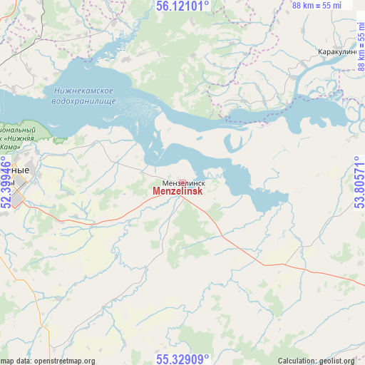
Menzelinsk GPS coordinates[2]
55° 43' 37.416" North, 53° 6' 9.288" East
| Map corner | latitude | longitude |
|---|---|---|
| Upper-left | 56.12101°, | 52.39946° |
| Center: | 55.72706°, | 53.10258° |
| Lower-right: | 55.32909°, | 53.80571° |
| Map W x H: | 88.1×88.1 km | = 54.7×54.7mi |
| max Lat: | 73.50819° ⇑37.7% North |
| Menzelinsk: | 55.72706° |
| min Lat: | ⇓62.3% South 41.28413° |
| min Long | Menzelinsk | max Long |
| -179.12198° | 53.10258° | 179.35046° |
| W 64.9%⇐ | ⇒35.1% E |
Elevation
Elevation of Menzelinsk is 98 m = 322 ft, and this is 104.6 m = 343 ft below average elevation for this country.
| Max E: |
2518 m = 8261 ft | 71.9% |
| Avg. | 202.6 m = 665 ft | |
| Menzelinsk | 98 m = 322 ft | |
Min E: |
-28 m = -92 ft | 28.1% |
See also: Russia elevation on elevation.city.
Geographical zone
Menzelinsk is located in North temperate zone (between Tropic of Cancer and the Arctic Circle). Distance of this North polar circle is 1204.9 km =748.7 mi to North.| Distance of | km | miles | from Menzelinsk |
|---|---|---|---|
| North Pole | 3810.8 | 2367.9 | to North |
| Arctic Circle | 1204.9 | 748.7 | to North |
| Tropic Cancer | 3590.3 | 2230.9 | to South |
| Equator | 6196.3 | 3850.2 | to South |


Nearby cities:
15 places around Menzelinsk: (largest is in red/bold)
• Agidel’
55.8 km =34.7 mi,  68°
68°
• Aktanysh
61.4 km =38.2 mi,  90°
90°
• Alnashi
64.2 km =39.9 mi,  322°
322°
• Bakaly
75.3 km =46.8 mi,  144°
144°
• Grakhovo
79.4 km =49.3 mi,  296°
296°
• Karakulino
49.2 km =30.6 mi,  49°
49°
• Kiyasovo
69.2 km =43 mi,  1°
1°
• Mendeleyevsk
54.6 km =33.9 mi,  291°
291°
• Muslyumovo
47.5 km =29.5 mi,  172°
172°
• Naberezhnyye Chelny
43.3 km =26.9 mi,  269°
269°
• Nikolo-Berëzovka
79.1 km =49.2 mi,  56°
56°
• Nizhnekamsk
80.7 km =50.1 mi,  262°
262°
• Sarmanovo
61.6 km =38.3 mi,  211°
211°
• Yelabuga
65.1 km =40.5 mi, 273°
• Zainsk
79.3 km =49.3 mi,  235°
235°
Sources, notices
• [Note1] Compared only with cities in Russia existing in our database
• [Src1] Map data: © OpenStreetMap contributors (CC-BY-SA)
• [Src2] Other city data from geonames.org with taken over terms of usage.
• [Src3] Geographical zone / Annual Mean Temperature by Robert A. Rohde @ Wikipedia
