Zimovniki geodata
Zimovniki (Rostov) is a seat of a second-order administrative division; located in Russia in Europe/Moscow (GMT+3) time zone. With population of 17,678 people, there are 971 cities with bigger population in this country. Compared to other cities in Russia, 82% of cities are located further ↑North; 58.4% of cities are located further →East and 81.7% of cities have higher elevation than Zimovniki. Note1


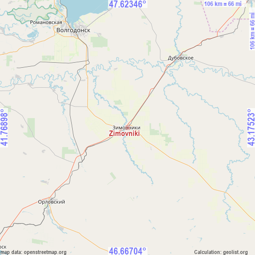
Zimovniki GPS coordinates[2]
47° 8' 50.64" North, 42° 28' 19.56" East
| Map corner | latitude | longitude |
|---|---|---|
| Upper-left | 47.62346°, | 41.76898° |
| Center: | 47.1474°, | 42.4721° |
| Lower-right: | 46.66704°, | 43.17523° |
| Map W x H: | 106.3×106.3 km | = 66.1×66.1mi |
| max Lat: | 73.50819° ⇑82% North |
| Zimovniki: | 47.1474° |
| min Lat: | ⇓18% South 41.28413° |
| min Long | Zimovniki | max Long |
| -179.12198° | 42.4721° | 179.35046° |
| W 41.6%⇐ | ⇒58.4% E |
Elevation
Elevation of Zimovniki is 65 m = 213 ft, and this is 137.6 m = 451 ft below average elevation for this country.
| Max E: |
2518 m = 8261 ft | 81.7% |
| Avg. | 202.6 m = 665 ft | |
| Zimovniki | 65 m = 213 ft | |
Min E: |
-28 m = -92 ft | 18.3% |
See also: Russia elevation on elevation.city.
Geographical zone
Zimovniki is located in North temperate zone (between Tropic of Cancer and the Arctic Circle). Distance of this North polar circle is 2158.9 km =1341.5 mi to North.| Distance of | km | miles | from Zimovniki |
|---|---|---|---|
| North Pole | 4764.8 | 2960.7 | to North |
| Arctic Circle | 2158.9 | 1341.5 | to North |
| Tropic Cancer | 2636.4 | 1638.2 | to South |
| Equator | 5242.3 | 3257.4 | to South |


Nearby cities:
15 places around Zimovniki: (largest is in red/bold)
• Bol’shaya Martynovka
62.4 km =38.8 mi,  283°
283°
• Dubovskoye
37.2 km =23.1 mi,  37°
37°
• Gundorovskiy
59.8 km =37.2 mi,  226°
226°
• Kotel’nikovo
73.6 km =45.7 mi, 43°
• Krasnoarmeyskiy
25.1 km =15.6 mi, 232°
• Krasnoyarskaya
44.3 km =27.5 mi,  330°
330°
• Krasnoyarskaya
64.5 km =40.1 mi, 330°
• Nikolayevskaya
89.6 km =55.7 mi,  305°
305°
• Orlovskiy
43.8 km =27.2 mi, 225°
• Proletarsk
75.1 km =46.7 mi, 228°
• Romanovskaya
55.2 km =34.3 mi,  322°
322°
• Sovetskoye
53.4 km =33.2 mi,  207°
207°
• Tsimlyansk
62.1 km =38.6 mi, 333°
• Volgodonsk
47.4 km =29.5 mi, 329°
• Volochayevskiy
68.4 km =42.5 mi,  168°
168°
Sources, notices
• [Note1] Compared only with cities in Russia existing in our database
• [Src1] Map data: © OpenStreetMap contributors (CC-BY-SA)
• [Src2] Other city data from geonames.org with taken over terms of usage.
• [Src3] Geographical zone / Annual Mean Temperature by Robert A. Rohde @ Wikipedia
