Gundorovskiy geodata
Gundorovskiy (Rostov) is a populated place; located in Russia in Europe/Moscow (GMT+3) time zone. With population of 5,210 people, there are 2555 cities with bigger population in this country. Compared to other cities in Russia, 82.5% of cities are located further ↑North; 60.1% of cities are located further →East and 80.9% of cities have higher elevation than Gundorovskiy. Note1


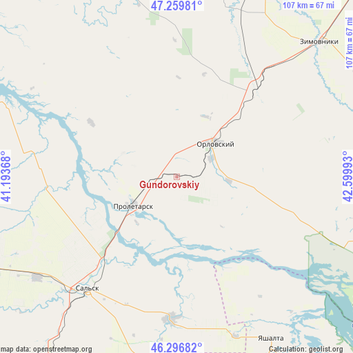
Gundorovskiy GPS coordinates[2]
46° 46' 49.692" North, 41° 53' 48.48" East
| Map corner | latitude | longitude |
|---|---|---|
| Upper-left | 47.25981°, | 41.19368° |
| Center: | 46.78047°, | 41.8968° |
| Lower-right: | 46.29682°, | 42.59993° |
| Map W x H: | 107.1×107.1 km | = 66.5×66.5mi |
| max Lat: | 73.50819° ⇑82.5% North |
| Gundorovskiy: | 46.78047° |
| min Lat: | ⇓17.5% South 41.28413° |
| min Long | Gundorovskiy | max Long |
| -179.12198° | 41.8968° | 179.35046° |
| W 39.9%⇐ | ⇒60.1% E |
Elevation
Elevation of Gundorovskiy is 68 m = 223 ft, and this is 134.6 m = 442 ft below average elevation for this country.
| Max E: |
2518 m = 8261 ft | 80.9% |
| Avg. | 202.6 m = 665 ft | |
| Gundorovskiy | 68 m = 223 ft | |
Min E: |
-28 m = -92 ft | 19.1% |
See also: Russia elevation on elevation.city.
Geographical zone
Gundorovskiy is located in North temperate zone (between Tropic of Cancer and the Arctic Circle). Distance of this North polar circle is 2199.7 km =1366.8 mi to North.| Distance of | km | miles | from Gundorovskiy |
|---|---|---|---|
| North Pole | 4805.6 | 2986.1 | to North |
| Arctic Circle | 2199.7 | 1366.8 | to North |
| Tropic Cancer | 2595.6 | 1612.8 | to South |
| Equator | 5201.5 | 3232.1 | to South |


Nearby cities:
15 places around Gundorovskiy: (largest is in red/bold)
• Bol’shaya Martynovka
57.6 km =35.8 mi,  342°
342°
• Gigant
52.2 km =32.4 mi,  234°
234°
• Gorodoviki
71.9 km =44.7 mi,  175°
175°
• Gorodovikovsk
77.1 km =47.9 mi, 177°
• Krasnoarmeyskiy
34.9 km =21.7 mi,  42°
42°
• Novyy Yegorlyk
43.2 km =26.8 mi, 182°
• Orlovskiy
16 km =9.9 mi,  50°
50°
• Proletarsk
15.5 km =9.6 mi,  236°
236°
• Sal’sk
43.5 km =27 mi,  218°
218°
• Sandata
57.7 km =35.9 mi,  190°
190°
• Sovetskoye
20.1 km =12.5 mi,  108°
108°
• Tselina
71.4 km =44.4 mi,  247°
247°
• Volochayevskiy
63.3 km =39.3 mi, 114°
• Yashalta
57 km =35.4 mi,  149°
149°
• Zimovniki
59.8 km =37.2 mi, 46°
Sources, notices
• [Note1] Compared only with cities in Russia existing in our database
• [Src1] Map data: © OpenStreetMap contributors (CC-BY-SA)
• [Src2] Other city data from geonames.org with taken over terms of usage.
• [Src3] Geographical zone / Annual Mean Temperature by Robert A. Rohde @ Wikipedia
