Mirnyy geodata
Mirnyy (Arkhangelskaya) is a populated place; located in Russia in Europe/Moscow (GMT+3) time zone. With population of 28,000 people, there are 702 cities with bigger population in this country. Compared to other cities in Russia, 96% of cities are located further ↓South; 65.9% of cities are located further →East and 65% of cities have higher elevation than Mirnyy. Note1


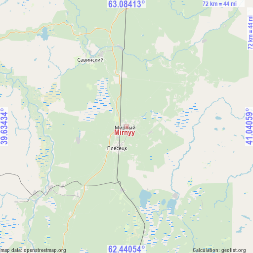
Mirnyy GPS coordinates[2]
62° 45' 50.724" North, 40° 20' 14.856" East
| Map corner | latitude | longitude |
|---|---|---|
| Upper-left | 63.08413°, | 39.63434° |
| Center: | 62.76409°, | 40.33746° |
| Lower-right: | 62.44054°, | 41.04059° |
| Map W x H: | 71.6×71.6 km | = 44.5×44.5mi |
| max Lat: | 73.50819° ⇑4% North |
| Mirnyy: | 62.76409° |
| min Lat: | ⇓96% South 41.28413° |
| min Long | Mirnyy | max Long |
| -179.12198° | 40.33746° | 179.35046° |
| W 34.1%⇐ | ⇒65.9% E |
Elevation
Elevation of Mirnyy is 114 m = 374 ft, and this is 88.6 m = 291 ft below average elevation for this country.
| Max E: |
2518 m = 8261 ft | 65% |
| Avg. | 202.6 m = 665 ft | |
| Mirnyy | 114 m = 374 ft | |
Min E: |
-28 m = -92 ft | 35% |
See also: Russia elevation on elevation.city.
Geographical zone
Mirnyy is located in North temperate zone (between Tropic of Cancer and the Arctic Circle). Distance of this North polar circle is 422.5 km =262.5 mi to North.| Distance of | km | miles | from Mirnyy |
|---|---|---|---|
| North Pole | 3028.3 | 1881.7 | to North |
| Arctic Circle | 422.5 | 262.5 | to North |
| Tropic Cancer | 4372.8 | 2717.1 | to South |
| Equator | 6978.7 | 4336.4 | to South |


Nearby cities:
15 places around Mirnyy: (largest is in red/bold)
• Arkhangelo-Shelokhovskaya
113.8 km =70.7 mi,  214°
214°
• Berëznik
120.8 km =75.1 mi,  85°
85°
• Kodino
111.8 km =69.5 mi,  341°
341°
• Konëvo
88.6 km =55.1 mi,  215°
215°
• Nyandoma
122.3 km =76 mi,  183°
183°
• Oksovskiy
28.5 km =17.7 mi,  231°
231°
• Plesetsk
6.7 km =4.2 mi,  200°
200°
• Puksoozero
23.7 km =14.7 mi,  144°
144°
• Rochegda
157.1 km =97.6 mi, 93°
• Samoded
94.3 km =58.6 mi,  5°
5°
• Shalakusha
60.1 km =37.3 mi, 184°
• Shelokhovskaya
114.3 km =71 mi, 213°
• Shenkursk
150.4 km =93.5 mi,  118°
118°
• Yemetsk
107 km =66.5 mi,  42°
42°
• Yemtsa
34.4 km =21.4 mi,  359°
359°
Sources, notices
• [Note1] Compared only with cities in Russia existing in our database
• [Src1] Map data: © OpenStreetMap contributors (CC-BY-SA)
• [Src2] Other city data from geonames.org with taken over terms of usage.
• [Src3] Geographical zone / Annual Mean Temperature by Robert A. Rohde @ Wikipedia
