Plesetsk geodata
Plesetsk (Arkhangelskaya) is a populated place; located in Russia in Europe/Moscow (GMT+3) time zone. With population of 10,870 people, there are 1392 cities with bigger population in this country. Compared to other cities in Russia, 95.9% of cities are located further ↓South; 66% of cities are located further →East and 57.3% of cities have higher elevation than Plesetsk. Note1


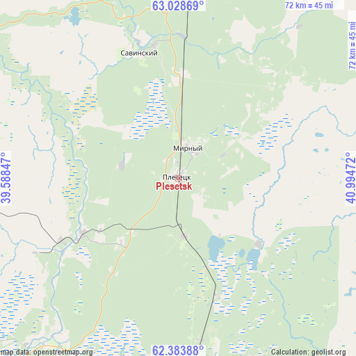
Plesetsk GPS coordinates[2]
62° 42' 28.944" North, 40° 17' 29.724" East
| Map corner | latitude | longitude |
|---|---|---|
| Upper-left | 63.02869°, | 39.58847° |
| Center: | 62.70804°, | 40.29159° |
| Lower-right: | 62.38388°, | 40.99472° |
| Map W x H: | 71.7×71.7 km | = 44.6×44.6mi |
| max Lat: | 73.50819° ⇑4.1% North |
| Plesetsk: | 62.70804° |
| min Lat: | ⇓95.9% South 41.28413° |
| min Long | Plesetsk | max Long |
| -179.12198° | 40.29159° | 179.35046° |
| W 34%⇐ | ⇒66% E |
Elevation
Elevation of Plesetsk is 130 m = 427 ft, and this is 72.6 m = 238 ft below average elevation for this country.
| Max E: |
2518 m = 8261 ft | 57.3% |
| Avg. | 202.6 m = 665 ft | |
| Plesetsk | 130 m = 427 ft | |
Min E: |
-28 m = -92 ft | 42.7% |
See also: Russia elevation on elevation.city.
Geographical zone
Plesetsk is located in North temperate zone (between Tropic of Cancer and the Arctic Circle). Distance of this North polar circle is 428.7 km =266.4 mi to North.| Distance of | km | miles | from Plesetsk |
|---|---|---|---|
| North Pole | 3034.6 | 1885.6 | to North |
| Arctic Circle | 428.7 | 266.4 | to North |
| Tropic Cancer | 4366.6 | 2713.3 | to South |
| Equator | 6972.5 | 4332.5 | to South |


Nearby cities:
15 places around Plesetsk: (largest is in red/bold)
• Arkhangelo-Shelokhovskaya
107.4 km =66.7 mi,  214°
214°
• Berëznik
123.9 km =77 mi,  82°
82°
• Kargopol’
151 km =93.8 mi, 207°
• Kodino
117.1 km =72.8 mi,  343°
343°
• Konëvo
82.2 km =51.1 mi,  216°
216°
• Mirnyy
6.7 km =4.2 mi,  20°
20°
• Nyandoma
116 km =72.1 mi,  182°
182°
• Oksovskiy
23 km =14.3 mi,  240°
240°
• Puksoozero
20.7 km =12.9 mi,  129°
129°
• Samoded
100.7 km =62.6 mi,  6°
6°
• Shalakusha
53.8 km =33.4 mi, 182°
• Shelokhovskaya
107.9 km =67 mi, 214°
• Shenkursk
149.7 km =93 mi,  116°
116°
• Yemetsk
113.2 km =70.3 mi,  41°
41°
• Yemtsa
40.7 km =25.3 mi,  2°
2°
Sources, notices
• [Note1] Compared only with cities in Russia existing in our database
• [Src1] Map data: © OpenStreetMap contributors (CC-BY-SA)
• [Src2] Other city data from geonames.org with taken over terms of usage.
• [Src3] Geographical zone / Annual Mean Temperature by Robert A. Rohde @ Wikipedia
