Yurgamysh geodata
Yurgamysh (Kurgan Oblast) is a populated place; located in Russia in Asia/Yekaterinburg (GMT+5) time zone. With population of 7,888 people, there are 1831 cities with bigger population in this country. Compared to other cities in Russia, 56.9% of cities are located further ↓South; 75.5% of cities are located further ←West and 53.5% of cities have lower elevation than Yurgamysh. Note1


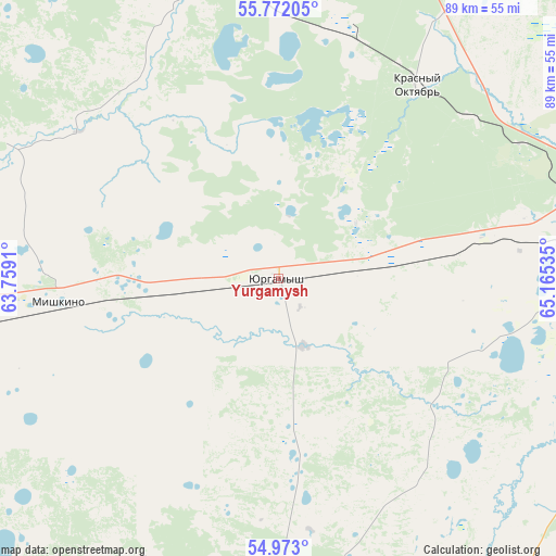
Yurgamysh GPS coordinates[2]
55° 22' 28.344" North, 64° 27' 43.992" East
| Map corner | latitude | longitude |
|---|---|---|
| Upper-left | 55.77205°, | 63.7591° |
| Center: | 55.37454°, | 64.46222° |
| Lower-right: | 54.973°, | 65.16535° |
| Map W x H: | 88.8×88.8 km | = 55.2×55.2mi |
| max Lat: | 73.50819° ⇑43.1% North |
| Yurgamysh: | 55.37454° |
| min Lat: | ⇓56.9% South 41.28413° |
| min Long | Yurgamysh | max Long |
| -179.12198° | 64.46222° | 179.35046° |
| W 75.5%⇐ | ⇒24.5% E |
Elevation
Elevation of Yurgamysh is 153 m = 502 ft, and this is 49.6 m = 163 ft below average elevation for this country.
| Max E: |
2518 m = 8261 ft | 46.5% |
| Avg. | 202.6 m = 665 ft | |
| Yurgamysh | 153 m = 502 ft | |
Min E: |
-28 m = -92 ft | 53.5% |
See also: Russia elevation on elevation.city.
Geographical zone
Yurgamysh is located in North temperate zone (between Tropic of Cancer and the Arctic Circle). Distance of this North polar circle is 1244.1 km =773 mi to North.| Distance of | km | miles | from Yurgamysh |
|---|---|---|---|
| North Pole | 3850 | 2392.3 | to North |
| Arctic Circle | 1244.1 | 773 | to North |
| Tropic Cancer | 3551.2 | 2206.6 | to South |
| Equator | 6157.1 | 3825.8 | to South |


Nearby cities:
15 places around Yurgamysh: (largest is in red/bold)
• Belozërskoye
86.2 km =53.6 mi,  54°
54°
• Glyadyanskoye
65.4 km =40.6 mi,  142°
142°
• Ikovka
39.7 km =24.7 mi, 48°
• Ketovo
54.6 km =33.9 mi,  92°
92°
• Krasnyy Oktyabr’
38.4 km =23.9 mi,  35°
35°
• Kurgan
55.6 km =34.5 mi,  81°
81°
• Kurtamysh
51.7 km =32.1 mi,  182°
182°
• Lesnikovo
55.1 km =34.2 mi,  100°
100°
• Mishkino
34.7 km =21.6 mi,  263°
263°
• Prosvet
44.7 km =27.8 mi,  60°
60°
• Shadrinsk
94.5 km =58.7 mi,  326°
326°
• Shumikha
75.6 km =47 mi, 257°
• Vargashi
87.5 km =54.4 mi, 91°
• Vvedenskoye
40.8 km =25.4 mi,  74°
74°
• Zverinogolovskoye
105.4 km =65.5 mi,  166°
166°
Sources, notices
• [Note1] Compared only with cities in Russia existing in our database
• [Src1] Map data: © OpenStreetMap contributors (CC-BY-SA)
• [Src2] Other city data from geonames.org with taken over terms of usage.
• [Src3] Geographical zone / Annual Mean Temperature by Robert A. Rohde @ Wikipedia
