Lesnikovo geodata
Lesnikovo (Kurgan Oblast) is a populated place; located in Russia in Asia/Yekaterinburg (GMT+5) time zone. With population of 5,864 people, there are 2310 cities with bigger population in this country. Compared to other cities in Russia, 55.9% of cities are located further ↓South; 75.9% of cities are located further ←West and 75.5% of cities have higher elevation than Lesnikovo. Note1


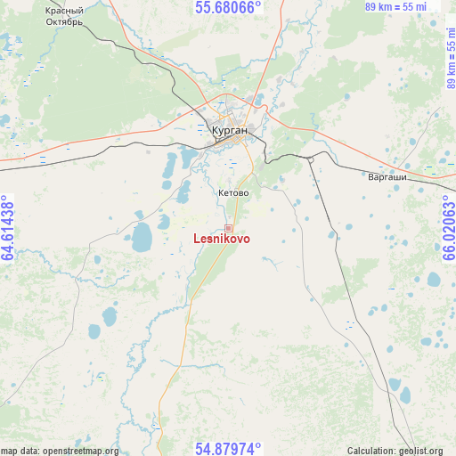
Lesnikovo GPS coordinates[2]
55° 16' 55.992" North, 65° 19' 3" East
| Map corner | latitude | longitude |
|---|---|---|
| Upper-left | 55.68066°, | 64.61438° |
| Center: | 55.28222°, | 65.3175° |
| Lower-right: | 54.87974°, | 66.02063° |
| Map W x H: | 89.1×89.1 km | = 55.4×55.4mi |
| max Lat: | 73.50819° ⇑44.1% North |
| Lesnikovo: | 55.28222° |
| min Lat: | ⇓55.9% South 41.28413° |
| min Long | Lesnikovo | max Long |
| -179.12198° | 65.3175° | 179.35046° |
| W 75.9%⇐ | ⇒24.1% E |
Elevation
Elevation of Lesnikovo is 86 m = 282 ft, and this is 116.6 m = 383 ft below average elevation for this country.
| Max E: |
2518 m = 8261 ft | 75.5% |
| Avg. | 202.6 m = 665 ft | |
| Lesnikovo | 86 m = 282 ft | |
Min E: |
-28 m = -92 ft | 24.5% |
See also: Russia elevation on elevation.city.
Geographical zone
Lesnikovo is located in North temperate zone (between Tropic of Cancer and the Arctic Circle). Distance of this North polar circle is 1254.4 km =779.4 mi to North.| Distance of | km | miles | from Lesnikovo |
|---|---|---|---|
| North Pole | 3860.3 | 2398.7 | to North |
| Arctic Circle | 1254.4 | 779.4 | to North |
| Tropic Cancer | 3540.9 | 2200.2 | to South |
| Equator | 6146.8 | 3819.4 | to South |


Nearby cities:
15 places around Lesnikovo: (largest is in red/bold)
• Belozërskoye
62.3 km =38.7 mi,  15°
15°
• Glyadyanskoye
44.1 km =27.4 mi,  199°
199°
• Ikovka
43.5 km =27 mi,  326°
326°
• Ketovo
8.1 km =5 mi,  3°
3°
• Krasnyy Oktyabr’
52.4 km =32.6 mi,  322°
322°
• Kurgan
18.7 km =11.6 mi, 3°
• Kurtamysh
69.9 km =43.4 mi,  233°
233°
• Lebyazh’ye
74.6 km =46.4 mi,  91°
91°
• Mishkino
88.8 km =55.2 mi,  274°
274°
• Polovinnoye
69.2 km =43 mi,  142°
142°
• Prosvet
35.3 km =21.9 mi,  335°
335°
• Vargashi
34.5 km =21.4 mi,  76°
76°
• Vvedenskoye
25.9 km =16.1 mi, 325°
• Yurgamysh
55.1 km =34.2 mi,  280°
280°
• Zverinogolovskoye
96.8 km =60.1 mi, 197°
Sources, notices
• [Note1] Compared only with cities in Russia existing in our database
• [Src1] Map data: © OpenStreetMap contributors (CC-BY-SA)
• [Src2] Other city data from geonames.org with taken over terms of usage.
• [Src3] Geographical zone / Annual Mean Temperature by Robert A. Rohde @ Wikipedia
