Ketovo geodata
Ketovo (Kurgan Oblast) is a populated place; located in Russia in Asia/Yekaterinburg (GMT+5) time zone. With population of 6,966 people, there are 2010 cities with bigger population in this country. Compared to other cities in Russia, 56.7% of cities are located further ↓South; 75.9% of cities are located further ←West and 79.2% of cities have higher elevation than Ketovo. Note1


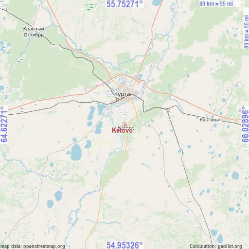
Ketovo GPS coordinates[2]
55° 21' 18" North, 65° 19' 32.988" East
| Map corner | latitude | longitude |
|---|---|---|
| Upper-left | 55.75271°, | 64.62271° |
| Center: | 55.355°, | 65.32583° |
| Lower-right: | 54.95326°, | 66.02896° |
| Map W x H: | 88.9×88.9 km | = 55.2×55.2mi |
| max Lat: | 73.50819° ⇑43.3% North |
| Ketovo: | 55.355° |
| min Lat: | ⇓56.7% South 41.28413° |
| min Long | Ketovo | max Long |
| -179.12198° | 65.32583° | 179.35046° |
| W 75.9%⇐ | ⇒24.1% E |
Elevation
Elevation of Ketovo is 73 m = 240 ft, and this is 129.6 m = 425 ft below average elevation for this country.
| Max E: |
2518 m = 8261 ft | 79.2% |
| Avg. | 202.6 m = 665 ft | |
| Ketovo | 73 m = 240 ft | |
Min E: |
-28 m = -92 ft | 20.8% |
See also: Russia elevation on elevation.city.
Geographical zone
Ketovo is located in North temperate zone (between Tropic of Cancer and the Arctic Circle). Distance of this North polar circle is 1246.3 km =774.4 mi to North.| Distance of | km | miles | from Ketovo |
|---|---|---|---|
| North Pole | 3852.2 | 2393.6 | to North |
| Arctic Circle | 1246.3 | 774.4 | to North |
| Tropic Cancer | 3549 | 2205.2 | to South |
| Equator | 6154.9 | 3824.5 | to South |


Nearby cities:
15 places around Ketovo: (largest is in red/bold)
• Belozërskoye
54.3 km =33.7 mi,  17°
17°
• Glyadyanskoye
52 km =32.3 mi,  196°
196°
• Ikovka
37.4 km =23.2 mi,  319°
319°
• Krasnyy Oktyabr’
46.5 km =28.9 mi, 316°
• Kurgan
10.6 km =6.6 mi,  2°
2°
• Kurtamysh
75.3 km =46.8 mi,  228°
228°
• Lebyazh’ye
74.6 km =46.4 mi,  97°
97°
• Lesnikovo
8.1 km =5 mi,  183°
183°
• Mishkino
89.1 km =55.4 mi,  268°
268°
• Mokrousovo
103.7 km =64.4 mi,  60°
60°
• Polovinnoye
75.5 km =46.9 mi,  146°
146°
• Prosvet
28.4 km =17.6 mi,  327°
327°
• Vargashi
32.9 km =20.4 mi,  89°
89°
• Vvedenskoye
20.2 km =12.6 mi,  311°
311°
• Yurgamysh
54.6 km =33.9 mi, 272°
Sources, notices
• [Note1] Compared only with cities in Russia existing in our database
• [Src1] Map data: © OpenStreetMap contributors (CC-BY-SA)
• [Src2] Other city data from geonames.org with taken over terms of usage.
• [Src3] Geographical zone / Annual Mean Temperature by Robert A. Rohde @ Wikipedia
