Kemerovo geodata
Kemerovo (Kemerovo Oblast) is a seat of a first-order administrative division; located in Russia in Asia/Novokuznetsk (GMT+7) time zone. With population of 477,090 people, there are 37 cities with bigger population in this country. Compared to other cities in Russia, 56.5% of cities are located further ↓South; 83.7% of cities are located further ←West and 54.6% of cities have higher elevation than Kemerovo. Note1


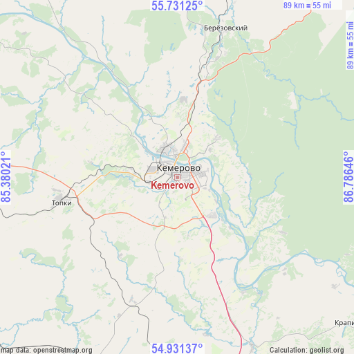
Kemerovo GPS coordinates[2]
55° 19' 59.988" North, 86° 4' 59.988" East
| Map corner | latitude | longitude |
|---|---|---|
| Upper-left | 55.73125°, | 85.38021° |
| Center: | 55.33333°, | 86.08333° |
| Lower-right: | 54.93137°, | 86.78646° |
| Map W x H: | 88.9×88.9 km | = 55.2×55.2mi |
| max Lat: | 73.50819° ⇑43.5% North |
| Kemerovo: | 55.33333° |
| min Lat: | ⇓56.5% South 41.28413° |
| min Long | Kemerovo | max Long |
| -179.12198° | 86.08333° | 179.35046° |
| W 83.7%⇐ | ⇒16.3% E |
Elevation
Elevation of Kemerovo is 135 m = 443 ft, and this is 67.6 m = 222 ft below average elevation for this country.
| Max E: |
2518 m = 8261 ft | 54.6% |
| Avg. | 202.6 m = 665 ft | |
| Kemerovo | 135 m = 443 ft | |
Min E: |
-28 m = -92 ft | 45.4% |
See also: Kemerovo elevation on elevation.city.
Geographical zone
Kemerovo is located in North temperate zone (between Tropic of Cancer and the Arctic Circle). Distance of this North polar circle is 1248.7 km =775.9 mi to North.| Distance of | km | miles | from Kemerovo |
|---|---|---|---|
| North Pole | 3854.6 | 2395.1 | to North |
| Arctic Circle | 1248.7 | 775.9 | to North |
| Tropic Cancer | 3546.6 | 2203.8 | to South |
| Equator | 6152.5 | 3823 | to South |


Nearby cities:
15 places around Kemerovo: (largest is in red/bold)
• Barzas
46.5 km =28.9 mi,  18°
18°
• Berëzovskiy
30.5 km =19 mi,  13°
13°
• Borovoy
11.1 km =6.9 mi,  0°
0°
• Kedrovka
22.3 km =13.9 mi,  354°
354°
• Krapivinskiy
59.4 km =36.9 mi,  128°
128°
• Leninsk-Kuznetsky
75.5 km =46.9 mi,  175°
175°
• Pioner
8.6 km =5.3 mi,  257°
257°
• Plotnikovo
35.4 km =22 mi,  194°
194°
• Promyshlennaya
54.4 km =33.8 mi,  211°
211°
• Promyshlennovskiy
18.2 km =11.3 mi, 23°
• Topki
30.2 km =18.8 mi, 258°
• Yagunovo
10.7 km =6.6 mi, 205°
• Yagunovskiy
8.7 km =5.4 mi,  229°
229°
• Yashkino
72.9 km =45.3 mi,  325°
325°
• Zelenogorskiy
67.1 km =41.7 mi,  119°
119°
Sources, notices
• [Note1] Compared only with cities in Russia existing in our database
• [Src1] Map data: © OpenStreetMap contributors (CC-BY-SA)
• [Src2] Other city data from geonames.org with taken over terms of usage.
• [Src3] Geographical zone / Annual Mean Temperature by Robert A. Rohde @ Wikipedia
