Topki geodata
Topki (Kemerovo Oblast) is a populated place; located in Russia in Asia/Novokuznetsk (GMT+7) time zone. With population of 30,572 people, there are 637 cities with bigger population in this country. Compared to other cities in Russia, 55.9% of cities are located further ↓South; 82.8% of cities are located further ←West and 82.7% of cities have lower elevation than Topki. Note1


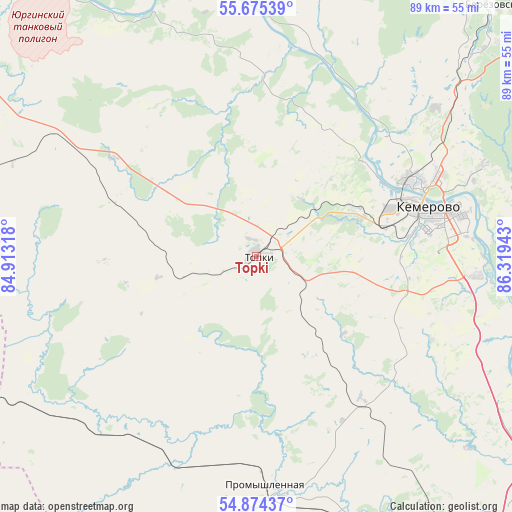
Topki GPS coordinates[2]
55° 16' 36.84" North, 85° 36' 58.68" East
| Map corner | latitude | longitude |
|---|---|---|
| Upper-left | 55.67539°, | 84.91318° |
| Center: | 55.2769°, | 85.6163° |
| Lower-right: | 54.87437°, | 86.31943° |
| Map W x H: | 89.1×89.1 km | = 55.4×55.4mi |
| max Lat: | 73.50819° ⇑44.1% North |
| Topki: | 55.2769° |
| min Lat: | ⇓55.9% South 41.28413° |
| min Long | Topki | max Long |
| -179.12198° | 85.6163° | 179.35046° |
| W 82.8%⇐ | ⇒17.2% E |
Elevation
Elevation of Topki is 281 m = 922 ft, and this is 78.4 m = 257 ft above average elevation for this country.
| Max E: |
2518 m = 8261 ft | 17.3% |
| Topki | 281 m 922 ft | |
| Avg. | 202.6 m = 665 ft | |
Min E: |
-28 m = -92 ft | 82.7% |
See also: Russia elevation on elevation.city.
Geographical zone
Topki is located in North temperate zone (between Tropic of Cancer and the Arctic Circle). Distance of this North polar circle is 1255 km =779.8 mi to North.| Distance of | km | miles | from Topki |
|---|---|---|---|
| North Pole | 3860.8 | 2399 | to North |
| Arctic Circle | 1255 | 779.8 | to North |
| Tropic Cancer | 3540.3 | 2199.8 | to South |
| Equator | 6146.2 | 3819.1 | to South |


Nearby cities:
15 places around Topki: (largest is in red/bold)
• Barzas
67.1 km =41.7 mi,  41°
41°
• Berëzovskiy
51.4 km =31.9 mi,  45°
45°
• Borovoy
34.3 km =21.3 mi,  59°
59°
• Kedrovka
39.5 km =24.5 mi, 43°
• Kemerovo
30.2 km =18.8 mi,  78°
78°
• Krasnoye
75.9 km =47.2 mi,  190°
190°
• Pioner
21.6 km =13.4 mi, 78°
• Plotnikovo
34.9 km =21.7 mi,  143°
143°
• Promyshlennaya
40.2 km =25 mi,  177°
177°
• Promyshlennovskiy
43.4 km =27 mi, 58°
• Yagunovo
25.2 km =15.7 mi,  97°
97°
• Yagunovskiy
22.9 km =14.2 mi,  88°
88°
• Yashkino
67.4 km =41.9 mi,  349°
349°
• Yurga
67.6 km =42 mi,  317°
317°
• Zhuravlevo
65.1 km =40.5 mi,  212°
212°
Sources, notices
• [Note1] Compared only with cities in Russia existing in our database
• [Src1] Map data: © OpenStreetMap contributors (CC-BY-SA)
• [Src2] Other city data from geonames.org with taken over terms of usage.
• [Src3] Geographical zone / Annual Mean Temperature by Robert A. Rohde @ Wikipedia
