Pioner geodata
Pioner (Kemerovo Oblast) is a populated place; located in Russia in Asia/Novokuznetsk (GMT+7) time zone. With population of 6,015 people, there are 2254 cities with bigger population in this country. Compared to other cities in Russia, 56.2% of cities are located further ↓South; 83.4% of cities are located further ←West and 55.3% of cities have lower elevation than Pioner. Note1


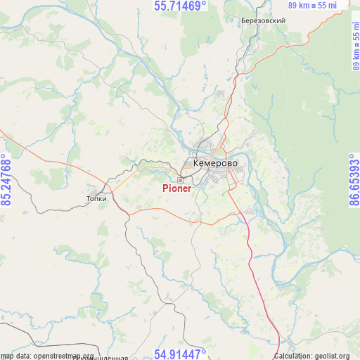
Pioner GPS coordinates[2]
55° 18' 59.76" North, 85° 57' 2.88" East
| Map corner | latitude | longitude |
|---|---|---|
| Upper-left | 55.71469°, | 85.24768° |
| Center: | 55.3166°, | 85.9508° |
| Lower-right: | 54.91447°, | 86.65393° |
| Map W x H: | 89×89 km | = 55.3×55.3mi |
| max Lat: | 73.50819° ⇑43.8% North |
| Pioner: | 55.3166° |
| min Lat: | ⇓56.2% South 41.28413° |
| min Long | Pioner | max Long |
| -179.12198° | 85.9508° | 179.35046° |
| W 83.4%⇐ | ⇒16.6% E |
Elevation
Elevation of Pioner is 157 m = 515 ft, and this is 45.6 m = 150 ft below average elevation for this country.
| Max E: |
2518 m = 8261 ft | 44.7% |
| Avg. | 202.6 m = 665 ft | |
| Pioner | 157 m = 515 ft | |
Min E: |
-28 m = -92 ft | 55.3% |
See also: Russia elevation on elevation.city.
Geographical zone
Pioner is located in North temperate zone (between Tropic of Cancer and the Arctic Circle). Distance of this North polar circle is 1250.5 km =777 mi to North.| Distance of | km | miles | from Pioner |
|---|---|---|---|
| North Pole | 3856.4 | 2396.3 | to North |
| Arctic Circle | 1250.5 | 777 | to North |
| Tropic Cancer | 3544.7 | 2202.6 | to South |
| Equator | 6150.6 | 3821.8 | to South |


Nearby cities:
15 places around Pioner: (largest is in red/bold)
• Barzas
51.5 km =32 mi,  27°
27°
• Berëzovskiy
35.2 km =21.9 mi, 26°
• Borovoy
15.4 km =9.6 mi, 32°
• Kedrovka
24.9 km =15.5 mi,  14°
14°
• Kemerovo
8.6 km =5.3 mi,  77°
77°
• Krapivinskiy
65.2 km =40.5 mi,  122°
122°
• Leninsk-Kuznetsky
74.7 km =46.4 mi,  169°
169°
• Plotnikovo
32.5 km =20.2 mi,  180°
180°
• Promyshlennaya
48.8 km =30.3 mi,  204°
204°
• Promyshlennovskiy
24.3 km =15.1 mi,  40°
40°
• Topki
21.6 km =13.4 mi,  258°
258°
• Yagunovo
8.7 km =5.4 mi,  153°
153°
• Yagunovskiy
4.1 km =2.5 mi,  155°
155°
• Yashkino
70.1 km =43.6 mi,  331°
331°
• Zelenogorskiy
73.7 km =45.8 mi, 115°
Sources, notices
• [Note1] Compared only with cities in Russia existing in our database
• [Src1] Map data: © OpenStreetMap contributors (CC-BY-SA)
• [Src2] Other city data from geonames.org with taken over terms of usage.
• [Src3] Geographical zone / Annual Mean Temperature by Robert A. Rohde @ Wikipedia
