Nagornyy geodata
Nagornyy (Altai Krai) is a populated place; located in Russia in Asia/Barnaul (GMT+7) time zone. With population of 6,308 people, there are 2176 cities with bigger population in this country. Compared to other cities in Russia, 64.1% of cities are located further ↑North; 80.9% of cities are located further ←West and 52.8% of cities have lower elevation than Nagornyy. Note1


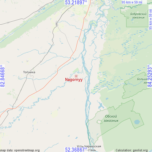
Nagornyy GPS coordinates[2]
52° 47' 45.24" North, 83° 32' 59.28" East
| Map corner | latitude | longitude |
|---|---|---|
| Upper-left | 53.21897°, | 82.84668° |
| Center: | 52.7959°, | 83.5498° |
| Lower-right: | 52.36867°, | 84.25293° |
| Map W x H: | 94.5×94.5 km | = 58.7×58.7mi |
| max Lat: | 73.50819° ⇑64.1% North |
| Nagornyy: | 52.7959° |
| min Lat: | ⇓35.9% South 41.28413° |
| min Long | Nagornyy | max Long |
| -179.12198° | 83.5498° | 179.35046° |
| W 80.9%⇐ | ⇒19.1% E |
Elevation
Elevation of Nagornyy is 151 m = 495 ft, and this is 51.6 m = 169 ft below average elevation for this country.
| Max E: |
2518 m = 8261 ft | 47.2% |
| Avg. | 202.6 m = 665 ft | |
| Nagornyy | 151 m = 495 ft | |
Min E: |
-28 m = -92 ft | 52.8% |
See also: Russia elevation on elevation.city.
Geographical zone
Nagornyy is located in North temperate zone (between Tropic of Cancer and the Arctic Circle). Distance of this North polar circle is 1530.8 km =951.2 mi to North.| Distance of | km | miles | from Nagornyy |
|---|---|---|---|
| North Pole | 4136.7 | 2570.4 | to North |
| Arctic Circle | 1530.8 | 951.2 | to North |
| Tropic Cancer | 3264.4 | 2028.4 | to South |
| Equator | 5870.4 | 3647.7 | to South |


Nearby cities:
15 places around Nagornyy: (largest is in red/bold)
• Bobrovka
48.3 km =30 mi,  26°
26°
• Cheremnoye
47.3 km =29.4 mi,  331°
331°
• Chernitsk
45.9 km =28.5 mi,  0°
0°
• Kalmanka
11.5 km =7.1 mi,  357°
357°
• Lebyazh’ye
50.3 km =31.3 mi,  7°
7°
• Lesnoy
57 km =35.4 mi, 29°
• Mokhnatushka
48.2 km =30 mi, 2°
• Novosilikatnyy
57.3 km =35.6 mi, 4°
• Novyye Zori
50.9 km =31.6 mi,  350°
350°
• Stukovo
48.5 km =30.1 mi,  342°
342°
• Topchikha
29.1 km =18.1 mi,  275°
275°
• Ust’-Charyshskaya Pristan’
45.4 km =28.2 mi,  170°
170°
• Vlasikha
55.8 km =34.7 mi, 1°
• Yuzhnyy
51.9 km =32.2 mi, 10°
• Zaton
58 km =36 mi,  17°
17°
Sources, notices
• [Note1] Compared only with cities in Russia existing in our database
• [Src1] Map data: © OpenStreetMap contributors (CC-BY-SA)
• [Src2] Other city data from geonames.org with taken over terms of usage.
• [Src3] Geographical zone / Annual Mean Temperature by Robert A. Rohde @ Wikipedia
