Uray geodata
Uray (Khanty-Mansia) is a populated place; located in Russia in Asia/Yekaterinburg (GMT+5) time zone. With population of 39,878 people, there are 527 cities with bigger population in this country. Compared to other cities in Russia, 91.1% of cities are located further ↓South; 75.7% of cities are located further ←West and 83.1% of cities have higher elevation than Uray. Note1


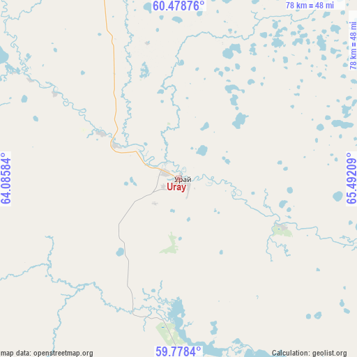
Uray GPS coordinates[2]
60° 7' 49.584" North, 64° 47' 20.256" East
| Map corner | latitude | longitude |
|---|---|---|
| Upper-left | 60.47876°, | 64.08584° |
| Center: | 60.13044°, | 64.78896° |
| Lower-right: | 59.7784°, | 65.49209° |
| Map W x H: | 77.9×77.9 km | = 48.4×48.4mi |
| max Lat: | 73.50819° ⇑8.9% North |
| Uray: | 60.13044° |
| min Lat: | ⇓91.1% South 41.28413° |
| min Long | Uray | max Long |
| -179.12198° | 64.78896° | 179.35046° |
| W 75.7%⇐ | ⇒24.3% E |
Elevation
Elevation of Uray is 57 m = 187 ft, and this is 145.6 m = 478 ft below average elevation for this country.
| Max E: |
2518 m = 8261 ft | 83.1% |
| Avg. | 202.6 m = 665 ft | |
| Uray | 57 m = 187 ft | |
Min E: |
-28 m = -92 ft | 16.9% |
See also: Russia elevation on elevation.city.
Geographical zone
Uray is located in North temperate zone (between Tropic of Cancer and the Arctic Circle). Distance of this North polar circle is 715.3 km =444.5 mi to North.| Distance of | km | miles | from Uray |
|---|---|---|---|
| North Pole | 3321.2 | 2063.7 | to North |
| Arctic Circle | 715.3 | 444.5 | to North |
| Tropic Cancer | 4080 | 2535.2 | to South |
| Equator | 6685.9 | 4154.4 | to South |


Nearby cities:
15 places around Uray: (largest is in red/bold)
• Gari
157.1 km =97.6 mi,  240°
240°
• Kommunisticheskiy
173 km =107.5 mi,  354°
354°
• Kondinskoye
155.7 km =96.7 mi,  110°
110°
• Kuminskiy
191.3 km =118.9 mi,  148°
148°
• Malinovskiy
159 km =98.8 mi,  318°
318°
• Mezhdurechenskiy
86.9 km =54 mi,  132°
132°
• Mortka
112.5 km =69.9 mi,  142°
142°
• Ous
198.6 km =123.4 mi,  295°
295°
• Pelym
181.2 km =112.6 mi, 302°
• Pionerskiy
157.9 km =98.1 mi, 318°
• Sos’va
195.9 km =121.7 mi, 237°
• Sovetskiy
151.7 km =94.3 mi,  334°
334°
• Tabory
179.6 km =111.6 mi,  184°
184°
• Yugorsk
153.5 km =95.4 mi, 328°
• Zelenoborsk
154.4 km =95.9 mi,  344°
344°
Sources, notices
• [Note1] Compared only with cities in Russia existing in our database
• [Src1] Map data: © OpenStreetMap contributors (CC-BY-SA)
• [Src2] Other city data from geonames.org with taken over terms of usage.
• [Src3] Geographical zone / Annual Mean Temperature by Robert A. Rohde @ Wikipedia
