Kommunisticheskiy geodata
Kommunisticheskiy (Khanty-Mansia) is a populated place; located in Russia in Asia/Yekaterinburg (GMT+5) time zone. With population of 2,690 people, there are 3893 cities with bigger population in this country. Compared to other cities in Russia, 94.2% of cities are located further ↓South; 75.6% of cities are located further ←West and 59.2% of cities have higher elevation than Kommunisticheskiy. Note1


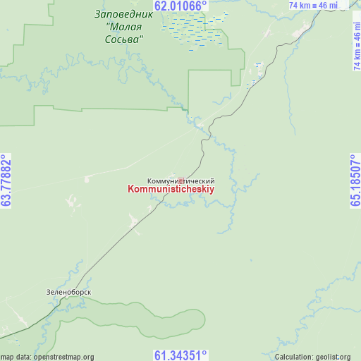
Kommunisticheskiy GPS coordinates[2]
61° 40' 44.004" North, 64° 28' 54.984" East
| Map corner | latitude | longitude |
|---|---|---|
| Upper-left | 62.01066°, | 63.77882° |
| Center: | 61.67889°, | 64.48194° |
| Lower-right: | 61.34351°, | 65.18507° |
| Map W x H: | 74.2×74.2 km | = 46.1×46.1mi |
| max Lat: | 73.50819° ⇑5.8% North |
| Kommunisticheskiy: | 61.67889° |
| min Lat: | ⇓94.2% South 41.28413° |
| min Long | Kommunistichesk | max Long |
| -179.12198° | 64.48194° | 179.35046° |
| W 75.6%⇐ | ⇒24.4% E |
Elevation
Elevation of Kommunisticheskiy is 126 m = 413 ft, and this is 76.6 m = 251 ft below average elevation for this country.
| Max E: |
2518 m = 8261 ft | 59.2% |
| Avg. | 202.6 m = 665 ft | |
| Kommunisticheskiy | 126 m = 413 ft | |
Min E: |
-28 m = -92 ft | 40.8% |
See also: Russia elevation on elevation.city.
Geographical zone
Kommunisticheskiy is located in North temperate zone (between Tropic of Cancer and the Arctic Circle). Distance of this North polar circle is 543.1 km =337.5 mi to North.| Distance of | km | miles | from Kommunisticheskiy |
|---|---|---|---|
| North Pole | 3149 | 1956.7 | to North |
| Arctic Circle | 543.1 | 337.5 | to North |
| Tropic Cancer | 4252.1 | 2642.1 | to South |
| Equator | 6858 | 4261.4 | to South |


Nearby cities:
15 places around Kommunisticheskiy: (largest is in red/bold)
• Agirish
81.4 km =50.6 mi,  289°
289°
• Andra
118.3 km =73.5 mi,  38°
38°
• Igrim
168.1 km =104.5 mi,  358°
358°
• Khulimsunt
197.2 km =122.5 mi,  311°
311°
• Malinovskiy
102.5 km =63.7 mi,  238°
238°
• Nyagan
70.1 km =43.6 mi, 42°
• Ous
180.1 km =111.9 mi, 241°
• Pelym
151.8 km =94.3 mi, 240°
• Pionerskiy
101.2 km =62.9 mi, 237°
• Priob’ye
110.1 km =68.4 mi,  31°
31°
• Sherkaly
130.6 km =81.2 mi,  23°
23°
• Sovetskiy
59.3 km =36.8 mi,  233°
233°
• Uray
173 km =107.5 mi,  174°
174°
• Yugorsk
73.4 km =45.6 mi, 236°
• Zelenoborsk
32.8 km =20.4 mi, 225°
Sources, notices
• [Note1] Compared only with cities in Russia existing in our database
• [Src1] Map data: © OpenStreetMap contributors (CC-BY-SA)
• [Src2] Other city data from geonames.org with taken over terms of usage.
• [Src3] Geographical zone / Annual Mean Temperature by Robert A. Rohde @ Wikipedia
