Uglovskoye geodata
Uglovskoye (Altai Krai) is a populated place; located in Russia in Asia/Barnaul (GMT+7) time zone. With population of 4,744 people, there are 2763 cities with bigger population in this country. Compared to other cities in Russia, 73.3% of cities are located further ↑North; 79.4% of cities are located further ←West and 67.4% of cities have lower elevation than Uglovskoye. Note1


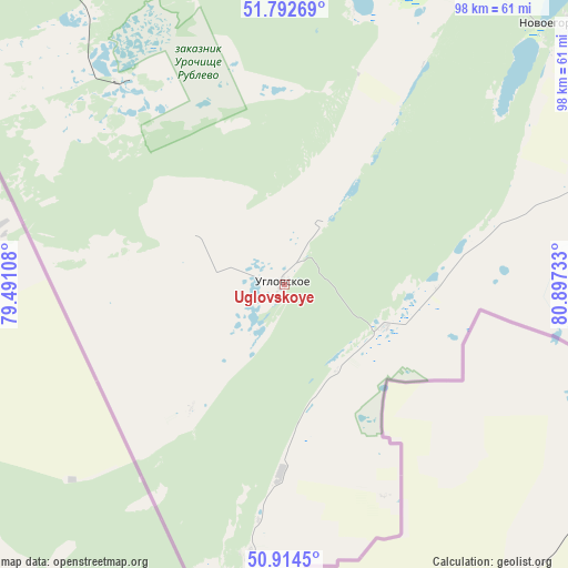
Uglovskoye GPS coordinates[2]
51° 21' 20.52" North, 80° 11' 39.12" East
| Map corner | latitude | longitude |
|---|---|---|
| Upper-left | 51.79269°, | 79.49108° |
| Center: | 51.3557°, | 80.1942° |
| Lower-right: | 50.9145°, | 80.89733° |
| Map W x H: | 97.6×97.6 km | = 60.6×60.6mi |
| max Lat: | 73.50819° ⇑73.3% North |
| Uglovskoye: | 51.3557° |
| min Lat: | ⇓26.7% South 41.28413° |
| min Long | Uglovskoye | max Long |
| -179.12198° | 80.1942° | 179.35046° |
| W 79.4%⇐ | ⇒20.6% E |
Elevation
Elevation of Uglovskoye is 189 m = 620 ft, and this is 13.6 m = 45 ft below average elevation for this country.
| Max E: |
2518 m = 8261 ft | 32.6% |
| Avg. | 202.6 m = 665 ft | |
| Uglovskoye | 189 m = 620 ft | |
Min E: |
-28 m = -92 ft | 67.4% |
See also: Russia elevation on elevation.city.
Geographical zone
Uglovskoye is located in North temperate zone (between Tropic of Cancer and the Arctic Circle). Distance of this North polar circle is 1691 km =1050.7 mi to North.| Distance of | km | miles | from Uglovskoye |
|---|---|---|---|
| North Pole | 4296.8 | 2669.9 | to North |
| Arctic Circle | 1691 | 1050.7 | to North |
| Tropic Cancer | 3104.3 | 1928.9 | to South |
| Equator | 5710.2 | 3548.2 | to South |


Nearby cities:
15 places around Uglovskoye: (largest is in red/bold)
• Bastan
74.8 km =46.5 mi,  318°
318°
• Gornyak
97.3 km =60.5 mi,  114°
114°
• Klyuchi
122.2 km =75.9 mi, 324°
• Malinovoye Ozero
45.5 km =28.3 mi, 321°
• Mikhaylovskoye
61.6 km =38.3 mi,  327°
327°
• Nikolayevka
83.1 km =51.6 mi, 319°
• Novichikha
125 km =77.7 mi,  41°
41°
• Pospelikha
127 km =78.9 mi,  58°
58°
• Rodino
127 km =78.9 mi,  0°
0°
• Rubtsovsk
72.3 km =44.9 mi,  75°
75°
• Severka
106.8 km =66.4 mi, 324°
• Staroaleyskoye
131.7 km =81.8 mi, 107°
• Veseloyarsk
63.9 km =39.7 mi,  96°
96°
• Volchikha
74 km =46 mi,  8°
8°
• Zmeinogorsk
141 km =87.6 mi, 98°
Sources, notices
• [Note1] Compared only with cities in Russia existing in our database
• [Src1] Map data: © OpenStreetMap contributors (CC-BY-SA)
• [Src2] Other city data from geonames.org with taken over terms of usage.
• [Src3] Geographical zone / Annual Mean Temperature by Robert A. Rohde @ Wikipedia
