Mikhaylovskoye geodata
Mikhaylovskoye (Altai Krai) is a populated place; located in Russia in Asia/Barnaul (GMT+7) time zone. With population of 11,467 people, there are 1329 cities with bigger population in this country. Compared to other cities in Russia, 70.4% of cities are located further ↑North; 79.3% of cities are located further ←West and 61.2% of cities have lower elevation than Mikhaylovskoye. Note1


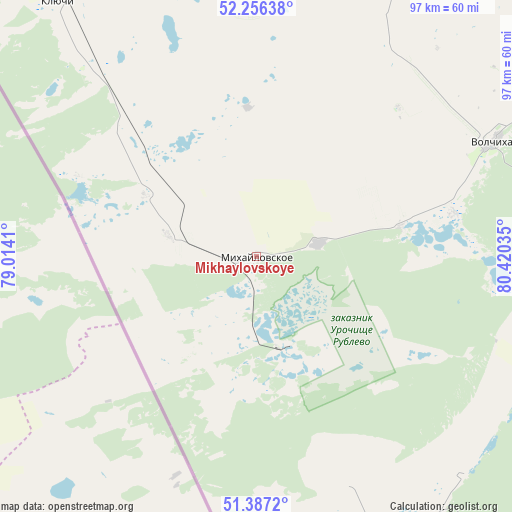
Mikhaylovskoye GPS coordinates[2]
51° 49' 26.004" North, 79° 43' 1.992" East
| Map corner | latitude | longitude |
|---|---|---|
| Upper-left | 52.25638°, | 79.0141° |
| Center: | 51.82389°, | 79.71722° |
| Lower-right: | 51.3872°, | 80.42035° |
| Map W x H: | 96.6×96.6 km | = 60×60mi |
| max Lat: | 73.50819° ⇑70.4% North |
| Mikhaylovskoye: | 51.82389° |
| min Lat: | ⇓29.6% South 41.28413° |
| min Long | Mikhaylovskoye | max Long |
| -179.12198° | 79.71722° | 179.35046° |
| W 79.3%⇐ | ⇒20.7% E |
Elevation
Elevation of Mikhaylovskoye is 172 m = 564 ft, and this is 30.6 m = 100 ft below average elevation for this country.
| Max E: |
2518 m = 8261 ft | 38.8% |
| Avg. | 202.6 m = 665 ft | |
| Mikhaylovskoye | 172 m = 564 ft | |
Min E: |
-28 m = -92 ft | 61.2% |
See also: Russia elevation on elevation.city.
Geographical zone
Mikhaylovskoye is located in North temperate zone (between Tropic of Cancer and the Arctic Circle). Distance of this North polar circle is 1638.9 km =1018.4 mi to North.| Distance of | km | miles | from Mikhaylovskoye |
|---|---|---|---|
| North Pole | 4244.8 | 2637.6 | to North |
| Arctic Circle | 1638.9 | 1018.4 | to North |
| Tropic Cancer | 3156.4 | 1961.3 | to South |
| Equator | 5762.3 | 3580.5 | to South |


Nearby cities:
15 places around Mikhaylovskoye: (largest is in red/bold)
• Bastan
17.1 km =10.6 mi,  283°
283°
• Blagoveshchenka
112.7 km =70 mi,  5°
5°
• Klyuchi
60.7 km =37.7 mi,  321°
321°
• Kulunda
98.1 km =61 mi,  327°
327°
• Malinovoye Ozero
17.1 km =10.6 mi,  164°
164°
• Nikolayevka
23.6 km =14.7 mi,  298°
298°
• Novichikha
121.9 km =75.7 mi,  69°
69°
• Rodino
81.9 km =50.9 mi,  23°
23°
• Romanovo
135.6 km =84.3 mi,  49°
49°
• Rubtsovsk
108.3 km =67.3 mi,  108°
108°
• Severka
45.5 km =28.3 mi, 319°
• Tabuny
123.4 km =76.7 mi, 329°
• Uglovskoye
61.6 km =38.3 mi,  147°
147°
• Veseloyarsk
113.1 km =70.3 mi,  121°
121°
• Volchikha
48.7 km =30.3 mi,  64°
64°
Sources, notices
• [Note1] Compared only with cities in Russia existing in our database
• [Src1] Map data: © OpenStreetMap contributors (CC-BY-SA)
• [Src2] Other city data from geonames.org with taken over terms of usage.
• [Src3] Geographical zone / Annual Mean Temperature by Robert A. Rohde @ Wikipedia
