Pervomayskiy geodata
Pervomayskiy (Altai Krai) is a populated place; located in Russia in Asia/Barnaul (GMT+7) time zone. With population of 5,238 people, there are 2539 cities with bigger population in this country. Compared to other cities in Russia, 63.3% of cities are located further ↑North; 79.8% of cities are located further ←West and 76.9% of cities have lower elevation than Pervomayskiy. Note1


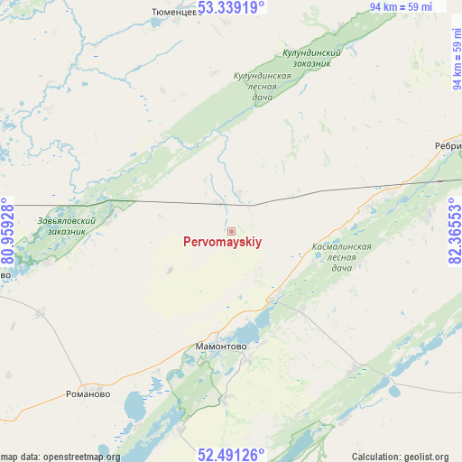
Pervomayskiy GPS coordinates[2]
52° 55' 2.28" North, 81° 39' 44.64" East
| Map corner | latitude | longitude |
|---|---|---|
| Upper-left | 53.33919°, | 80.95928° |
| Center: | 52.9173°, | 81.6624° |
| Lower-right: | 52.49126°, | 82.36553° |
| Map W x H: | 94.3×94.3 km | = 58.6×58.6mi |
| max Lat: | 73.50819° ⇑63.3% North |
| Pervomayskiy: | 52.9173° |
| min Lat: | ⇓36.7% South 41.28413° |
| min Long | Pervomayskiy | max Long |
| -179.12198° | 81.6624° | 179.35046° |
| W 79.8%⇐ | ⇒20.2% E |
Elevation
Elevation of Pervomayskiy is 226 m = 741 ft, and this is 23.4 m = 77 ft above average elevation for this country.
| Max E: |
2518 m = 8261 ft | 23.1% |
| Pervomayskiy | 226 m 741 ft | |
| Avg. | 202.6 m = 665 ft | |
Min E: |
-28 m = -92 ft | 76.9% |
See also: Russia elevation on elevation.city.
Geographical zone
Pervomayskiy is located in North temperate zone (between Tropic of Cancer and the Arctic Circle). Distance of this North polar circle is 1517.3 km =942.8 mi to North.| Distance of | km | miles | from Pervomayskiy |
|---|---|---|---|
| North Pole | 4123.2 | 2562 | to North |
| Arctic Circle | 1517.3 | 942.8 | to North |
| Tropic Cancer | 3277.9 | 2036.8 | to South |
| Equator | 5883.9 | 3656.1 | to South |


Nearby cities:
15 places around Pervomayskiy: (largest is in red/bold)
• Aleysk
89 km =55.3 mi,  122°
122°
• Bayevo
70.9 km =44.1 mi,  303°
303°
• Inya
93.7 km =58.2 mi,  45°
45°
• Kamen’-na-Obi
99.2 km =61.6 mi,  347°
347°
• Mamontovo
23.7 km =14.7 mi,  186°
186°
• Novichikha
81.5 km =50.6 mi, 193°
• Pavlovsk
98.7 km =61.3 mi,  63°
63°
• Rebrikha
48.6 km =30.2 mi,  69°
69°
• Romanovo
44.3 km =27.5 mi,  221°
221°
• Shelabolikha
84.2 km =52.3 mi, 49°
• Shipunovo
92.4 km =57.4 mi,  156°
156°
• Suzun
105.6 km =65.6 mi,  24°
24°
• Topchikha
98.3 km =61.1 mi,  96°
96°
• Tyumentsevo
46.4 km =28.8 mi, 346°
• Zav’yalovo
50.6 km =31.4 mi,  259°
259°
Sources, notices
• [Note1] Compared only with cities in Russia existing in our database
• [Src1] Map data: © OpenStreetMap contributors (CC-BY-SA)
• [Src2] Other city data from geonames.org with taken over terms of usage.
• [Src3] Geographical zone / Annual Mean Temperature by Robert A. Rohde @ Wikipedia
