Bayevo geodata
Bayevo (Altai Krai) is a populated place; located in Russia in Asia/Barnaul (GMT+7) time zone. With population of 5,134 people, there are 2592 cities with bigger population in this country. Compared to other cities in Russia, 60.6% of cities are located further ↑North; 79.5% of cities are located further ←West and 61.4% of cities have higher elevation than Bayevo. Note1


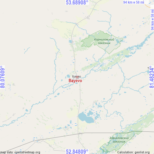
Bayevo GPS coordinates[2]
53° 16' 14.34" North, 80° 46' 45.156" East
| Map corner | latitude | longitude |
|---|---|---|
| Upper-left | 53.68908°, | 80.07609° |
| Center: | 53.27065°, | 80.77921° |
| Lower-right: | 52.84809°, | 81.48234° |
| Map W x H: | 93.5×93.5 km | = 58.1×58.1mi |
| max Lat: | 73.50819° ⇑60.6% North |
| Bayevo: | 53.27065° |
| min Lat: | ⇓39.4% South 41.28413° |
| min Long | Bayevo | max Long |
| -179.12198° | 80.77921° | 179.35046° |
| W 79.5%⇐ | ⇒20.5% E |
Elevation
Elevation of Bayevo is 121 m = 397 ft, and this is 81.6 m = 268 ft below average elevation for this country.
| Max E: |
2518 m = 8261 ft | 61.4% |
| Avg. | 202.6 m = 665 ft | |
| Bayevo | 121 m = 397 ft | |
Min E: |
-28 m = -92 ft | 38.6% |
See also: Russia elevation on elevation.city.
Geographical zone
Bayevo is located in North temperate zone (between Tropic of Cancer and the Arctic Circle). Distance of this North polar circle is 1478 km =918.4 mi to North.| Distance of | km | miles | from Bayevo |
|---|---|---|---|
| North Pole | 4083.9 | 2537.6 | to North |
| Arctic Circle | 1478 | 918.4 | to North |
| Tropic Cancer | 3317.2 | 2061.2 | to South |
| Equator | 5923.1 | 3680.4 | to South |


Nearby cities:
15 places around Bayevo: (largest is in red/bold)
• Blagoveshchenka
78 km =48.5 mi,  231°
231°
• Kamen’-na-Obi
68.5 km =42.6 mi,  32°
32°
• Khabary
91.4 km =56.8 mi,  295°
295°
• Krutikha
81.7 km =50.8 mi,  20°
20°
• Mamontovo
84.6 km =52.6 mi,  138°
138°
• Pankrushikha
68.8 km =42.8 mi,  335°
335°
• Pervomayskiy
70.9 km =44.1 mi,  123°
123°
• Polovinnoye
115 km =71.5 mi, 298°
• Rebrikha
106.4 km =66.1 mi,  101°
101°
• Rodino
94.2 km =58.5 mi,  204°
204°
• Romanovo
78.5 km =48.8 mi,  157°
157°
• Suzun
116.3 km =72.3 mi,  60°
60°
• Tyumentsevo
48.1 km =29.9 mi,  83°
83°
• Verkh-Suetka
48.8 km =30.3 mi,  274°
274°
• Zav’yalovo
49 km =30.4 mi,  168°
168°
Sources, notices
• [Note1] Compared only with cities in Russia existing in our database
• [Src1] Map data: © OpenStreetMap contributors (CC-BY-SA)
• [Src2] Other city data from geonames.org with taken over terms of usage.
• [Src3] Geographical zone / Annual Mean Temperature by Robert A. Rohde @ Wikipedia
