Shipunovo geodata
Shipunovo (Altai Krai) is a populated place; located in Russia in Asia/Barnaul (GMT+7) time zone. With population of 11,431 people, there are 1330 cities with bigger population in this country. Compared to other cities in Russia, 68.3% of cities are located further ↑North; 80% of cities are located further ←West and 65% of cities have lower elevation than Shipunovo. Note1


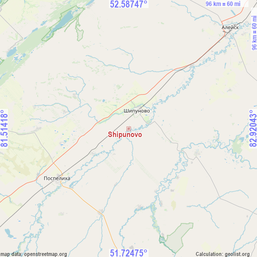
Shipunovo GPS coordinates[2]
52° 9' 29.52" North, 82° 13' 2.28" East
| Map corner | latitude | longitude |
|---|---|---|
| Upper-left | 52.58747°, | 81.51418° |
| Center: | 52.1582°, | 82.2173° |
| Lower-right: | 51.72475°, | 82.92043° |
| Map W x H: | 95.9×95.9 km | = 59.6×59.6mi |
| max Lat: | 73.50819° ⇑68.3% North |
| Shipunovo: | 52.1582° |
| min Lat: | ⇓31.7% South 41.28413° |
| min Long | Shipunovo | max Long |
| -179.12198° | 82.2173° | 179.35046° |
| W 80%⇐ | ⇒20% E |
Elevation
Elevation of Shipunovo is 182 m = 597 ft, and this is 20.6 m = 68 ft below average elevation for this country.
| Max E: |
2518 m = 8261 ft | 35% |
| Avg. | 202.6 m = 665 ft | |
| Shipunovo | 182 m = 597 ft | |
Min E: |
-28 m = -92 ft | 65% |
See also: Russia elevation on elevation.city.
Geographical zone
Shipunovo is located in North temperate zone (between Tropic of Cancer and the Arctic Circle). Distance of this North polar circle is 1601.7 km =995.2 mi to North.| Distance of | km | miles | from Shipunovo |
|---|---|---|---|
| North Pole | 4207.6 | 2614.5 | to North |
| Arctic Circle | 1601.7 | 995.2 | to North |
| Tropic Cancer | 3193.5 | 1984.3 | to South |
| Equator | 5799.4 | 3603.6 | to South |


Nearby cities:
15 places around Shipunovo: (largest is in red/bold)
• Aleysk
53.4 km =33.2 mi,  45°
45°
• Krasnoshchekovo
64.6 km =40.1 mi,  147°
147°
• Mamontovo
72.9 km =45.3 mi,  326°
326°
• Nagornyy
114.8 km =71.3 mi, 51°
• Novichikha
56.8 km =35.3 mi,  275°
275°
• Pervomayskiy
92.4 km =57.4 mi,  336°
336°
• Pospelikha
38.5 km =23.9 mi,  233°
233°
• Rebrikha
102.1 km =63.4 mi,  4°
4°
• Romanovo
84.4 km =52.4 mi,  307°
307°
• Rubtsovsk
99.7 km =62 mi,  224°
224°
• Topchikha
95.5 km =59.3 mi,  39°
39°
• Ust’-Charyshskaya Pristan’
101.8 km =63.3 mi,  75°
75°
• Ust’-Kalmanka
74.3 km =46.2 mi,  93°
93°
• Zav’yalovo
115.9 km =72 mi, 310°
• Zmeinogorsk
111.2 km =69.1 mi,  180°
180°
Sources, notices
• [Note1] Compared only with cities in Russia existing in our database
• [Src1] Map data: © OpenStreetMap contributors (CC-BY-SA)
• [Src2] Other city data from geonames.org with taken over terms of usage.
• [Src3] Geographical zone / Annual Mean Temperature by Robert A. Rohde @ Wikipedia
