Mamontovo geodata
Mamontovo (Altai Krai) is a populated place; located in Russia in Asia/Barnaul (GMT+7) time zone. With population of 9,275 people, there are 1618 cities with bigger population in this country. Compared to other cities in Russia, 64.8% of cities are located further ↑North; 79.8% of cities are located further ←West and 74% of cities have lower elevation than Mamontovo. Note1


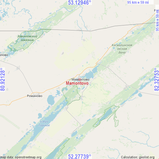
Mamontovo GPS coordinates[2]
52° 42' 19.8" North, 81° 37' 27.84" East
| Map corner | latitude | longitude |
|---|---|---|
| Upper-left | 53.12946°, | 80.92128° |
| Center: | 52.7055°, | 81.6244° |
| Lower-right: | 52.27739°, | 82.32753° |
| Map W x H: | 94.7×94.7 km | = 58.8×58.8mi |
| max Lat: | 73.50819° ⇑64.8% North |
| Mamontovo: | 52.7055° |
| min Lat: | ⇓35.2% South 41.28413° |
| min Long | Mamontovo | max Long |
| -179.12198° | 81.6244° | 179.35046° |
| W 79.8%⇐ | ⇒20.2% E |
Elevation
Elevation of Mamontovo is 212 m = 696 ft, and this is 9.4 m = 31 ft above average elevation for this country.
| Max E: |
2518 m = 8261 ft | 26% |
| Mamontovo | 212 m 696 ft | |
| Avg. | 202.6 m = 665 ft | |
Min E: |
-28 m = -92 ft | 74% |
See also: Russia elevation on elevation.city.
Geographical zone
Mamontovo is located in North temperate zone (between Tropic of Cancer and the Arctic Circle). Distance of this North polar circle is 1540.9 km =957.5 mi to North.| Distance of | km | miles | from Mamontovo |
|---|---|---|---|
| North Pole | 4146.8 | 2576.7 | to North |
| Arctic Circle | 1540.9 | 957.5 | to North |
| Tropic Cancer | 3254.4 | 2022.2 | to South |
| Equator | 5860.3 | 3641.4 | to South |


Nearby cities:
15 places around Mamontovo: (largest is in red/bold)
• Aleysk
81.7 km =50.8 mi,  106°
106°
• Bayevo
84.6 km =52.6 mi,  318°
318°
• Inya
113 km =70.2 mi,  38°
38°
• Novichikha
58 km =36 mi,  196°
196°
• Pavlovsk
113.6 km =70.6 mi,  53°
53°
• Pervomayskiy
23.7 km =14.7 mi,  6°
6°
• Pospelikha
84.6 km =52.6 mi,  173°
173°
• Rebrikha
63.1 km =39.2 mi, 49°
• Rodino
98.7 km =61.3 mi,  256°
256°
• Romanovo
28.5 km =17.7 mi,  250°
250°
• Shelabolikha
102.9 km =63.9 mi, 40°
• Shipunovo
72.9 km =45.3 mi,  146°
146°
• Topchikha
101.3 km =62.9 mi,  82°
82°
• Tyumentsevo
69.1 km =42.9 mi,  352°
352°
• Zav’yalovo
49.6 km =30.8 mi,  287°
287°
Sources, notices
• [Note1] Compared only with cities in Russia existing in our database
• [Src1] Map data: © OpenStreetMap contributors (CC-BY-SA)
• [Src2] Other city data from geonames.org with taken over terms of usage.
• [Src3] Geographical zone / Annual Mean Temperature by Robert A. Rohde @ Wikipedia
