Tyumentsevo geodata
Tyumentsevo (Altai Krai) is a populated place; located in Russia in Asia/Barnaul (GMT+7) time zone. With population of 5,759 people, there are 2344 cities with bigger population in this country. Compared to other cities in Russia, 60.1% of cities are located further ↑North; 79.8% of cities are located further ←West and 56.3% of cities have lower elevation than Tyumentsevo. Note1


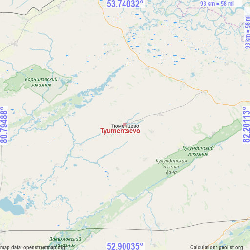
Tyumentsevo GPS coordinates[2]
53° 19' 20.64" North, 81° 29' 52.8" East
| Map corner | latitude | longitude |
|---|---|---|
| Upper-left | 53.74032°, | 80.79488° |
| Center: | 53.3224°, | 81.498° |
| Lower-right: | 52.90035°, | 82.20113° |
| Map W x H: | 93.4×93.4 km | = 58×58mi |
| max Lat: | 73.50819° ⇑60.1% North |
| Tyumentsevo: | 53.3224° |
| min Lat: | ⇓39.9% South 41.28413° |
| min Long | Tyumentsevo | max Long |
| -179.12198° | 81.498° | 179.35046° |
| W 79.8%⇐ | ⇒20.2% E |
Elevation
Elevation of Tyumentsevo is 159 m = 522 ft, and this is 43.6 m = 143 ft below average elevation for this country.
| Max E: |
2518 m = 8261 ft | 43.7% |
| Avg. | 202.6 m = 665 ft | |
| Tyumentsevo | 159 m = 522 ft | |
Min E: |
-28 m = -92 ft | 56.3% |
See also: Russia elevation on elevation.city.
Geographical zone
Tyumentsevo is located in North temperate zone (between Tropic of Cancer and the Arctic Circle). Distance of this North polar circle is 1472.3 km =914.8 mi to North.| Distance of | km | miles | from Tyumentsevo |
|---|---|---|---|
| North Pole | 4078.2 | 2534.1 | to North |
| Arctic Circle | 1472.3 | 914.8 | to North |
| Tropic Cancer | 3323 | 2064.8 | to South |
| Equator | 5928.9 | 3684 | to South |


Nearby cities:
15 places around Tyumentsevo: (largest is in red/bold)
• Bayevo
48.1 km =29.9 mi,  263°
263°
• Cheremnoye
115.4 km =71.7 mi,  98°
98°
• Inya
80.3 km =49.9 mi,  75°
75°
• Kamen’-na-Obi
52.8 km =32.8 mi,  348°
348°
• Krutikha
73.4 km =45.6 mi,  344°
344°
• Mamontovo
69.1 km =42.9 mi,  172°
172°
• Pankrushikha
95.1 km =59.1 mi,  306°
306°
• Pavlovsk
98.6 km =61.3 mi,  90°
90°
• Pervomayskiy
46.4 km =28.8 mi, 166°
• Rebrikha
62.6 km =38.9 mi,  116°
116°
• Romanovo
80.4 km =50 mi,  193°
193°
• Shelabolikha
74.9 km =46.5 mi, 82°
• Suzun
74.3 km =46.2 mi,  46°
46°
• Verkh-Suetka
96.4 km =59.9 mi,  268°
268°
• Zav’yalovo
66.3 km =41.2 mi,  215°
215°
Sources, notices
• [Note1] Compared only with cities in Russia existing in our database
• [Src1] Map data: © OpenStreetMap contributors (CC-BY-SA)
• [Src2] Other city data from geonames.org with taken over terms of usage.
• [Src3] Geographical zone / Annual Mean Temperature by Robert A. Rohde @ Wikipedia
